1:50,000 இலங்கையின் இடவிளக்கப் படங்கள்
\"படத்தை எழுதி நன்றாக படிக்கச் சொல்லுங்கள்\" — பரீட்சையில் வரும் commonest instruction. தரம் 10-ல் \"படங்களுக்கு ஓர் அறிமுகம்\" கற்றோம் — map என்றால் என்ன, scale, color, north arrow. இந்த அலகில் இலங்கையின் 1:50,000 இடவிளக்கப் படத்தை ஆழமாக வாசிக்கப் பயில்வோம் — (1) grid references (4-fig + 6-fig), (2) contour interpretation + landforms, (3) drainage patterns + rivers, (4) cultural features + symbols, (5) area + distance + gradient calculations, (6) cross-section drawing. இது ★5 unit — பரீட்சையில் highest mark allocation. Map skills + numerical accuracy crucial.
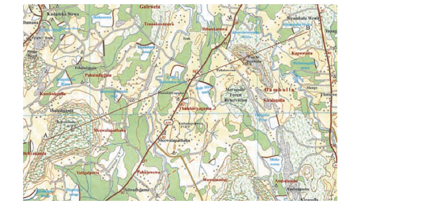
1. Sheet Basics — Recap
- SL 92 topographic sheets @ 1:50,000 scale.
- Each sheet: 5\' × 5\' graticule; ground ~9 km × 9 km ≈ 81 km²; map face ~80 cm × 80 cm.
- 1 cm map = 500 m ground; 2 cm = 1 km; 1 cm² = 0.25 km².
- Sri Lanka Survey Department (SDSL) Colombo prepares.
- 5 reading steps: title+sheet → scale → adjacent sheets → key → grid+north arrow → map face.
2. Grid System (கட்டக் குறிப்பு)
Topographic sheet-இல் blue / black grid lines vertical + horizontal forming 1 km × 1 km squares. Numbered: vertical lines (going north-south) = Eastings (read horizontally from left to right); horizontal lines (going east-west) = Northings (read vertically from bottom to top).
Reading rule: \"Along the corridor, then up the stairs\"
Always read Eastings (left-right) first, then Northings (bottom-up). அதாவது: x then y. Civilian + military standard.
4-Figure Grid Reference (Square reference)
To identify a 1 km × 1 km square (not a point) — use 4 digits:
- Read the Easting line on the west side of the square (lower number).
- Read the Northing line on the south side of the square (lower number).
- Combine: \"34 56\" means easting 34, northing 56 — this square.
Useful for: identifying a settlement, hill, lake within ~1 km × 1 km area.
6-Figure Grid Reference (Point reference)
To pinpoint a specific feature within a square — divide each side of the square mentally into 10 parts (100 m each), and read tenths:
- 4-figure square reference (e.g. \"34 56\").
- From within the square, estimate how many tenths east of the western Easting line the feature lies (0-9): say 6.
- How many tenths north of the southern Northing line: say 3.
- Combine: \"346 563\" — the digit 6 inserted after 34, and 3 inserted after 56.
Format: EEEnnn → e.g. \"346 563\" means Easting 34.6, Northing 56.3 = within 100 m × 100 m of the actual feature.
Common error: reversing Easting/Northing order. Mnemonic: \"EASTing before YOU NORTH\" (E before N alphabetically too).
3. Contour Lines + Landforms
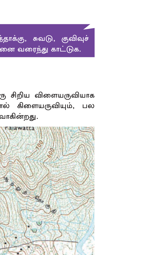
Contour line (சமவுயரக் கோடு): ஒரே elevation கொண்ட points-ஐ இணைக்கும் line. Brown color on SL 1:50,000 sheets. Contour interval (CI) = vertical distance between two consecutive contours. SL topo maps: 10 m or 20 m CI typical (depending on terrain).
Contour reading rules
- Close contours = steep slope.
- Spaced contours = gentle slope.
- Concentric closed loops = hill/peak — innermost loop highest.
- Closed loops with hachure ticks pointing in = depression/basin.
- Contours forming V pointing UP-slope = ridge.
- Contours forming V pointing DOWN-slope (towards lower contour) = valley.
- Every 5th contour = "index contour" — thicker line, labeled with elevation.
Identifying Landforms
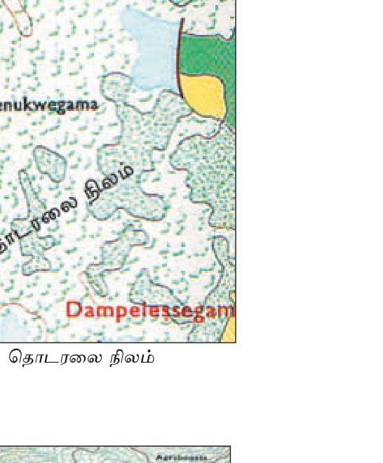
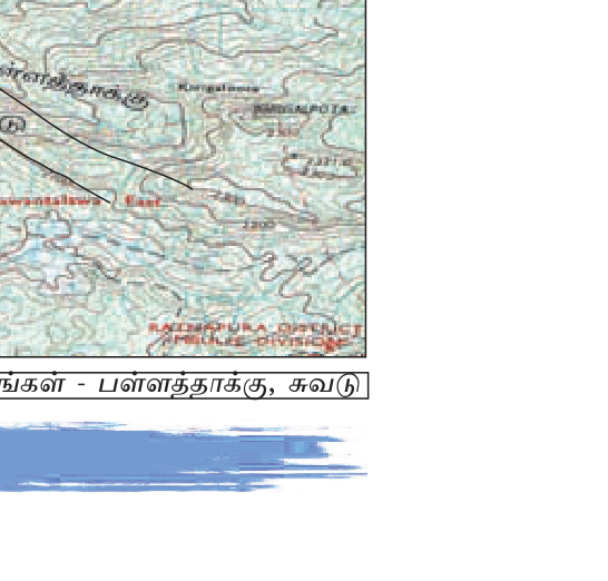
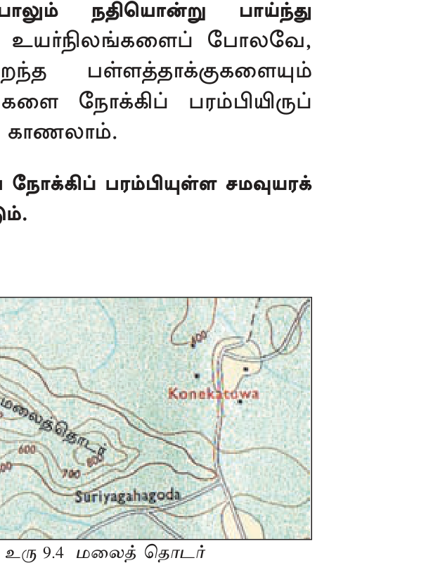
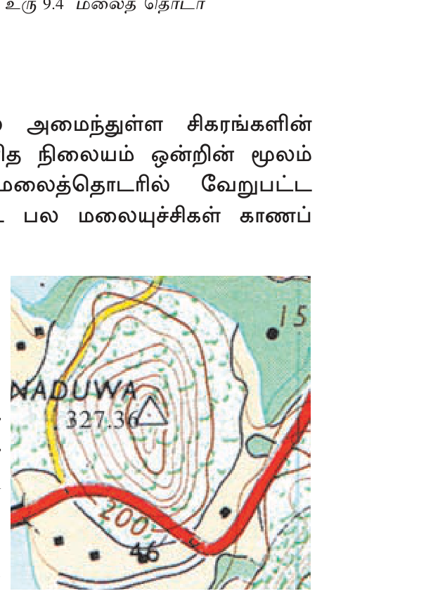
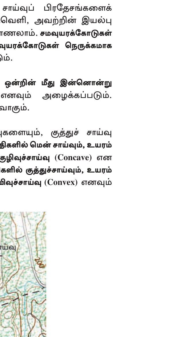

4. Drainage Patterns (வடிகால் முறை)
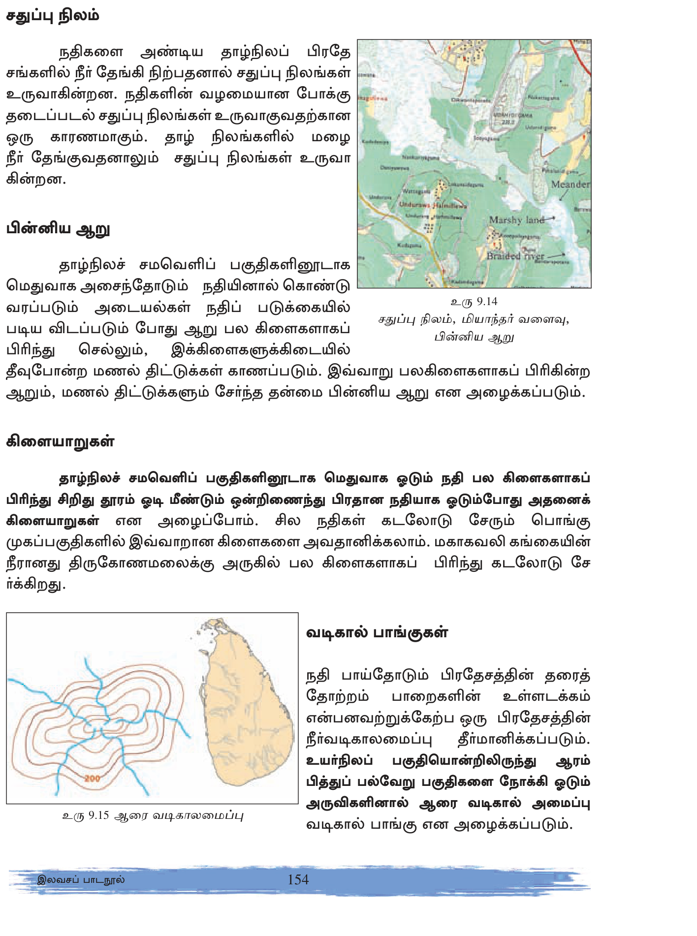
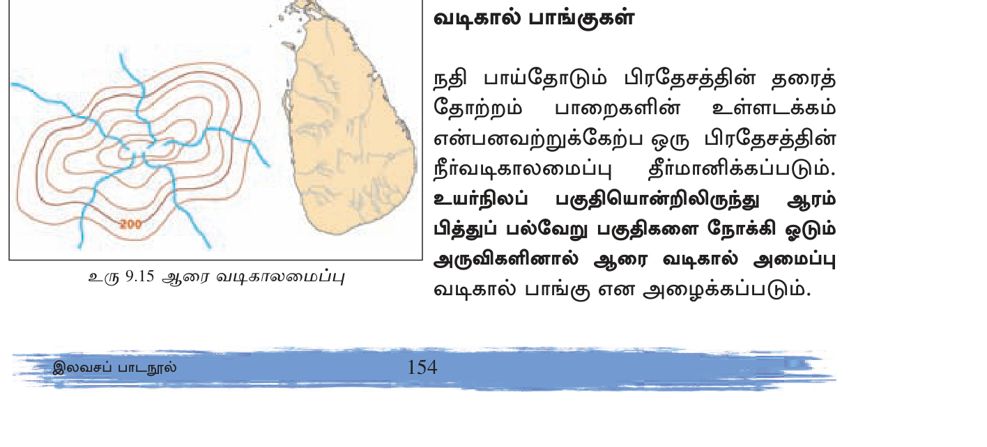
Major patterns
- Dendritic (மரக்கொம்பு) — tree-branching; most common; uniform soft rock terrain (Mahaweli, Kelani SL).
- Trellis (கம்பி) — perpendicular crossings; folded sedimentary terrain.
- Rectangular — right-angle bends; jointed/faulted rock.
- Radial — streams emanating from central peak; volcanic cones or hills.
- Centripetal — flowing toward center; basin lake.
- Parallel — slope-controlled.
- Annular — circular around domed/eroded structure.
- Deranged (இணைப்பற்ற) — chaotic; recent glaciation or surface disruption.
River-related features
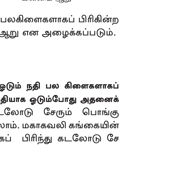
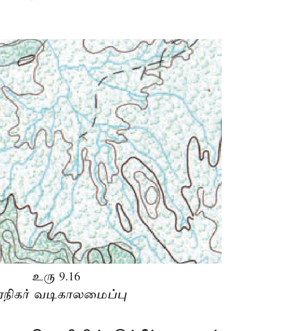
- Confluence (சங்கமம்) — two streams join.
- Tributary (உப ஆறு) — smaller river joining larger.
- Distributary (மருதலவி) — river dividing into channels (delta).
- Meander (கினைப் பாறை) — looping bends in mature river.
- Oxbow lake — abandoned meander loop.
- Braided river — multiple interweaving channels with sediment.
- Waterfall — sudden elevation drop; closely-spaced contours crossing stream.
- Rapids — fast-flowing rocky section.
5. Coastal Features (கடற்கரை அம்சங்கள்)
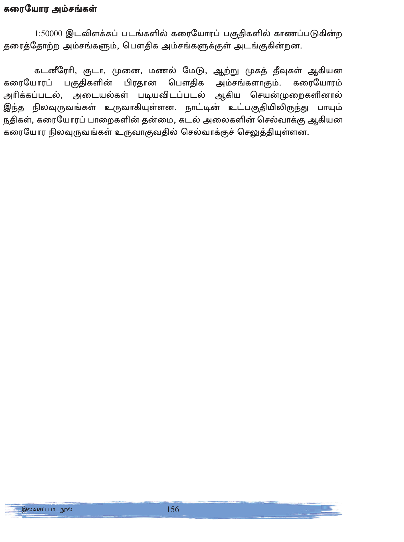
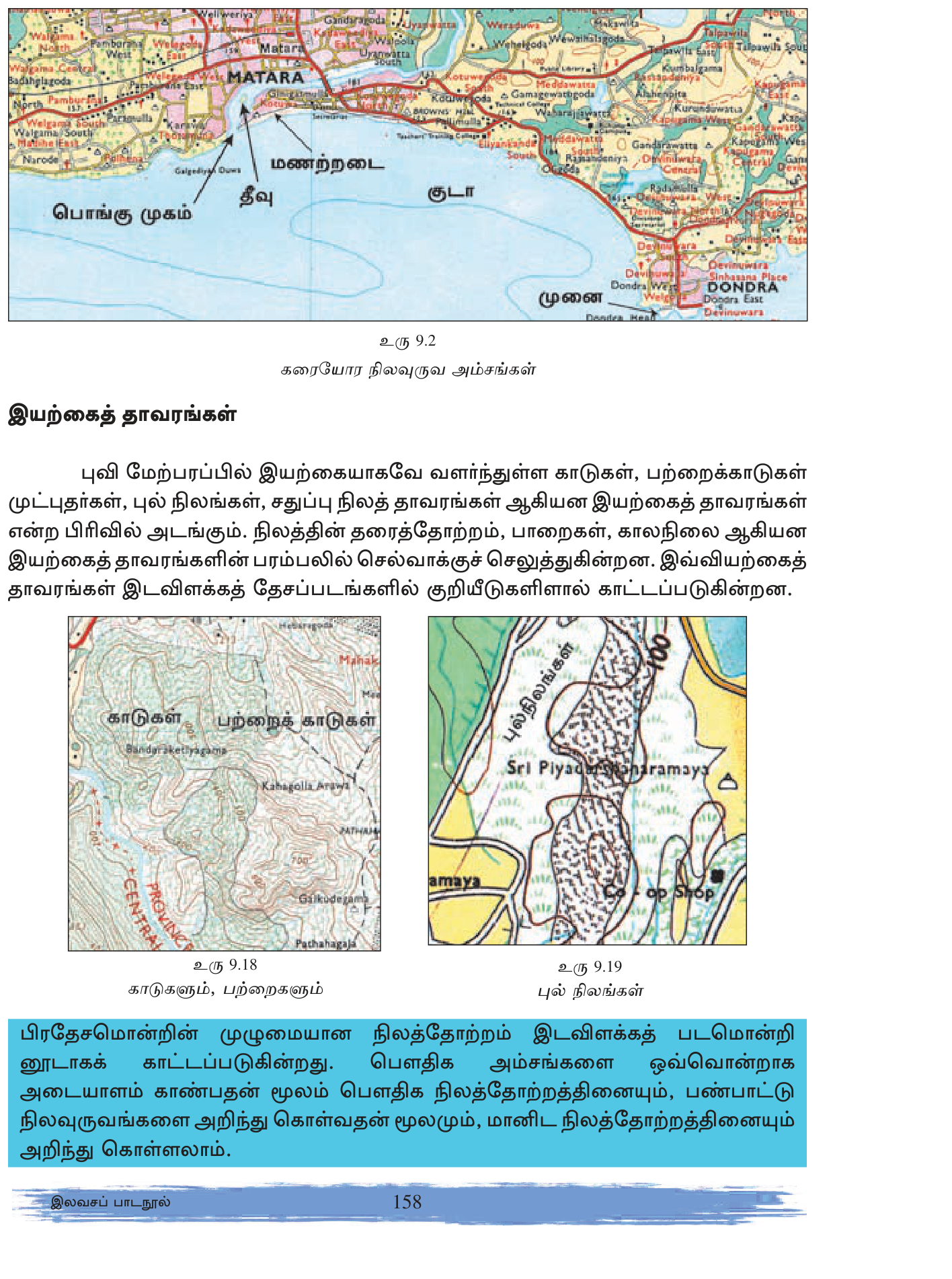
- Headland / Cape (முனை) — projecting land into sea.
- Bay / Gulf (கூடம்) — sea curving into land.
- Estuary — river mouth where freshwater + sea mix.
- Lagoon — partially-enclosed coastal water (Negombo, Madu Ganga, Batticaloa).
- Delta — river-built triangular landform at mouth.
- Spit / Sandbar — coastal narrow projection.
- Island — land surrounded by water.
- Peninsula — land surrounded on three sides (Jaffna Peninsula).
- Reef — submerged ridge.
- Beach — sandy/pebbly coastal strip.
6. Cultural Features (பண்பாட்டு அம்சங்கள்)
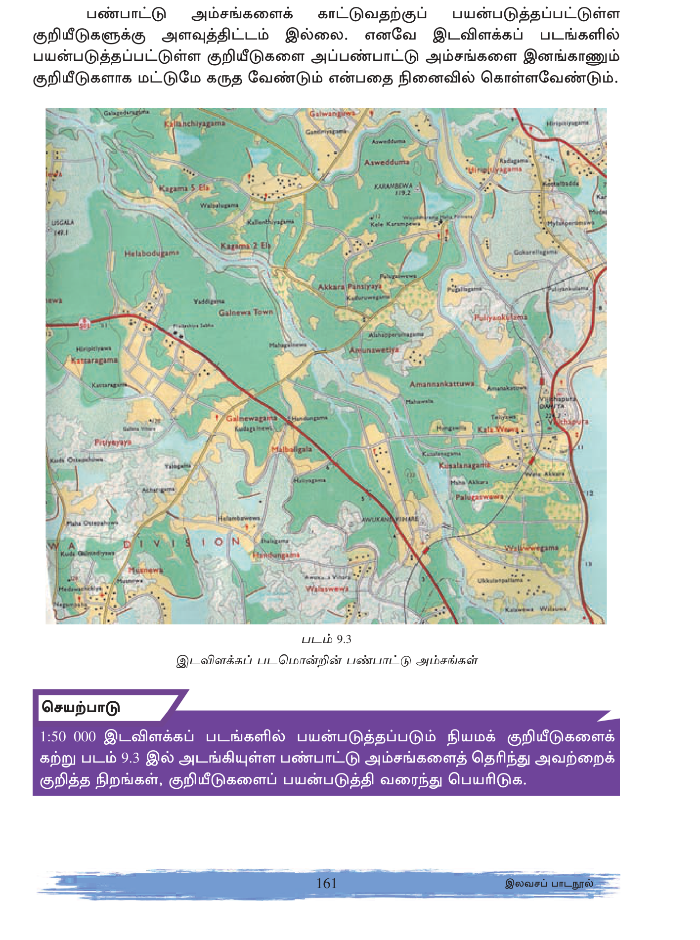
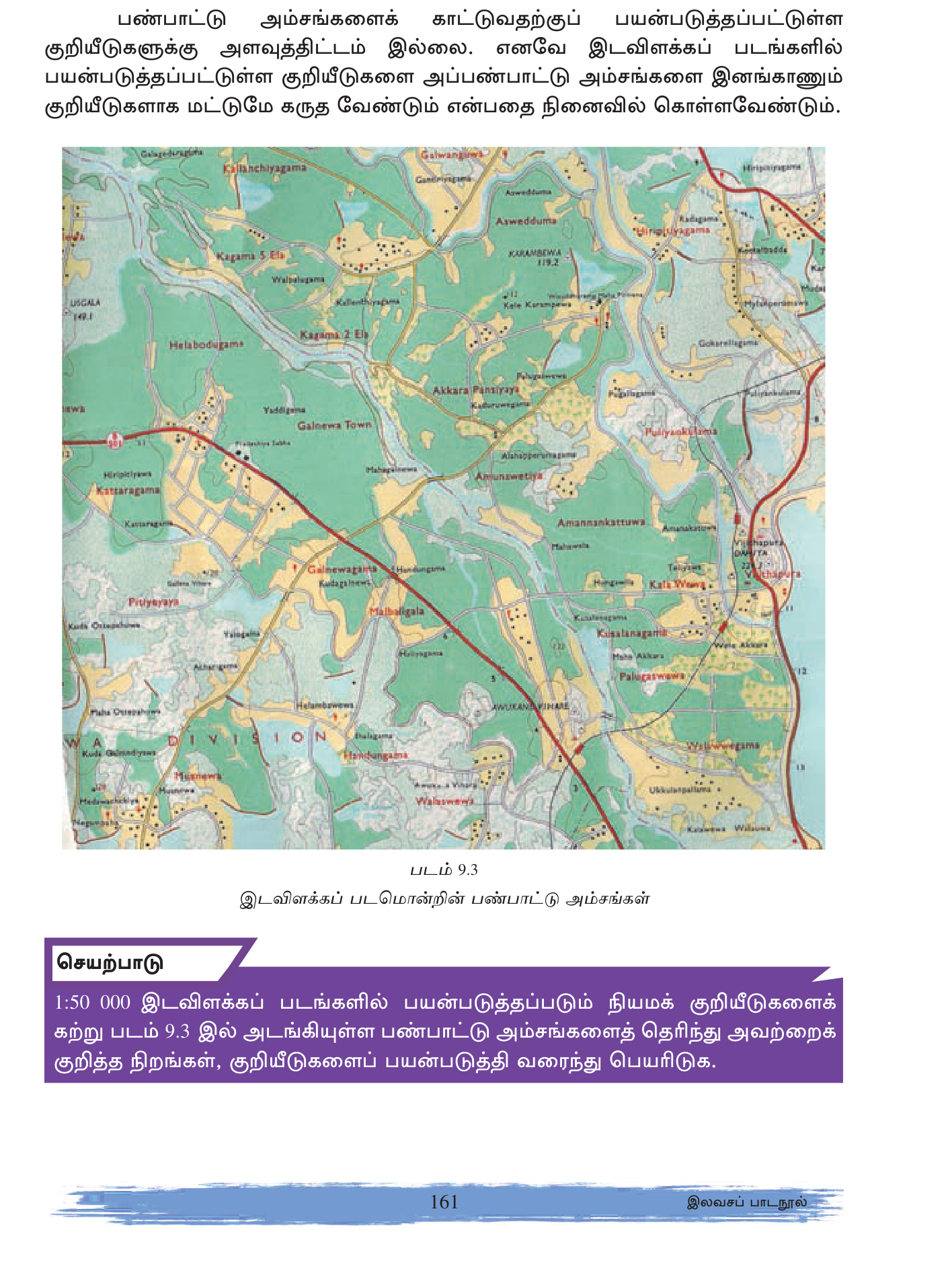
Settlements (குடியிருப்புகள்)
- Dispersed (சிதறிய): isolated houses spread across area; rural agricultural.
- Nucleated (குவிந்த): houses clustered around centre; village + town.
- Linear (கோட்டில்): houses along roads/rivers/coastlines.
- Compact urban — dense built-up shading.
Transport
- A class road = solid double red.
- B class road = solid single red.
- C/D class = dashed red.
- Footpath / cart track = dashed black.
- Railway = solid black with ties.
- Bridge = double parallel curves.
Religious + Civic
- Buddhist temple = dagoba/pagoda symbol.
- Hindu temple = கோயில் symbol.
- Mosque = crescent.
- Church = cross.
- Police station = \"P\".
- Post office = \"PO\".
- School = single building.
- Hospital = red cross.
7. Calculations (கணிப்புகள்)
Distance
- Straight line: measure cm with ruler × 0.5 km/cm. e.g., 5.4 cm = 2.7 km.
- Curving road/river: use thread/string to follow curves; measure straightened.
- Or use compass/divider in small segments.
Area
- Regular shape (rectangle): measure length × breadth in cm² × 0.25 km²/cm² = area.
- Square count method: count complete grid squares + half-squares × 1 km²/square.
- e.g., 8 complete squares + 4 half squares = 8 + 2 = 10 km².
Gradient / Slope (சரிவின் சாய்வு)
Gradient = vertical rise ÷ horizontal distance. Expressed as ratio (1:25) or percentage (4%).
Example: peak 800m, valley 200m, horizontal distance 3 km between them.
Rise = 800-200 = 600 m.
Distance = 3000 m.
Gradient = 600/3000 = 1:5 or 20%.
Classification: 1:5 = very steep; 1:20 = steep; 1:50 = moderate; 1:100 = gentle.
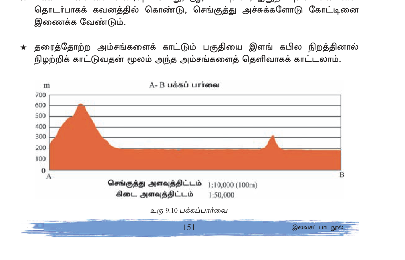
Cross-Section (குறுக்கு வெட்டு)
Draw vertical profile along a chosen line:
- Choose section line (e.g. from A to B on map).
- Mark each contour intersection with the line + note elevation.
- On graph paper, plot horizontal axis = distance (using map scale); vertical axis = elevation.
- Mark each contour point + connect smoothly.
- Use exaggerated vertical scale for visibility (~10×).
Shows ridges, valleys, peaks at glance.
8. Sample Map Interpretation Exercise
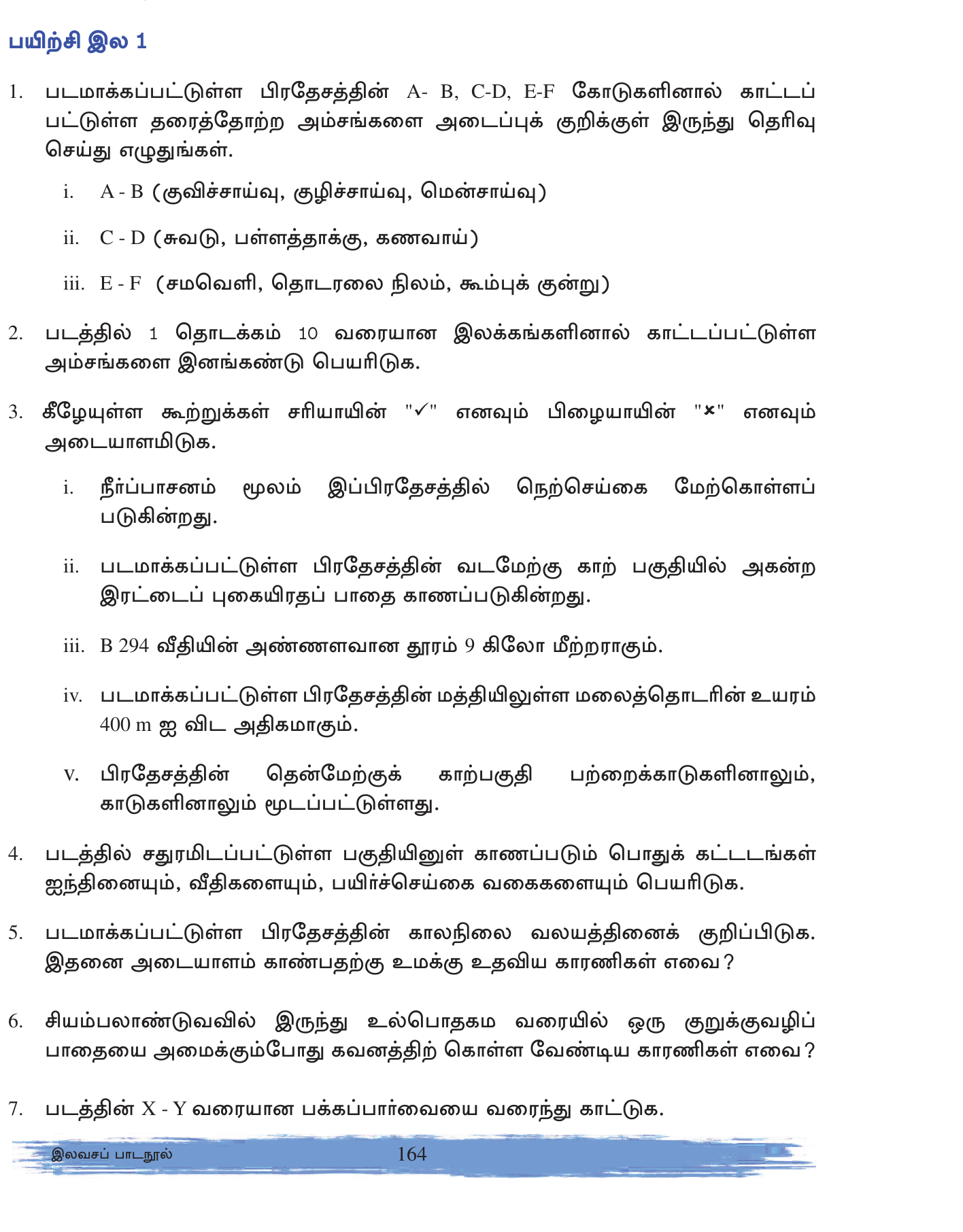
Typical exam tasks:
- Give 6-figure grid reference for a specific feature.
- Calculate distance between two points (straight + along road).
- Identify type of slope between two contours.
- Name + describe one drainage pattern visible.
- Identify one landform (hill/valley/plateau).
- List settlement type + transport features.
- Calculate area of a specified region.
- Calculate gradient between two points.
- Draw a cross-section along a given line.
- Suggest land use possibilities based on topography.
- SL 92 topographic sheets @ 1:50,000. 1 cm = 500 m; 2 cm = 1 km; 1 cm² = 0.25 km².
- 5 reading steps: title → scale → adjacent → key → grid+north.
- Grid: Eastings first, then Northings. 4-fig = square; 6-fig = point within square.
- Contour interval: 10 or 20 m on SL maps. Index contour every 5th = thicker.
- Close contours = steep; spaced = gentle. Concentric closed = peak.
- V contours up-slope = ridge; V down-slope = valley.
- Drainage patterns: Dendritic (common), Trellis, Rectangular, Radial, Centripetal, Parallel, Annular, Deranged.
- Colors: Blue=water, Brown=contour, Red=roads+admin, Black=settlements+railway, Green=paddy, Yellow=plantation/track.
- Area methods: regular shape rectangle; square count for irregular.
- Gradient = rise/run. 1:5=20% very steep; 1:100=1% gentle.
- Cross-section = vertical profile along selected line.
- Eastings vs Northings: Eastings FIRST (along corridor), then Northings (up the stairs). \"E before N alphabetically.\"
- 4-fig vs 6-fig: 4-fig identifies 1×1 km square; 6-fig pinpoints 100m × 100m. Confusing exact format common error.
- 1 cm² ≠ 1 km² — square the linear ratio. 1 cm² = (0.5 km)² = 0.25 km².
- Brown contour line NOT blue (that\'s water). Yellow = paddy/tracks. Green = paddy fields.
- V pointing up-slope = ridge; V pointing down-slope = valley. Easy to reverse.
- Gradient should be a RATIO or %; not unit-less number. 1:5 or 20%.
- Cross-section: use exaggerated vertical scale (~10×) for visual clarity; mark scale clearly.
- \"Dendritic\" = tree-shape — most common pattern in SL.
- Adjacent sheet check: at margin not center; helps continuation.
✅ விரைவுச் சோதனை
முக்கியக் கருத்துக்களை உறுதிப்படுத்துங்கள். தவறான விடைகள் உங்கள் தவறுக் குறிப்பேட்டில் சேமிக்கப்படும்.
🖊 கட்டுரை வினாக்கள் (பகுதி II)
பரீட்சை வடிவில் கட்டமைப்பு வினாக்கள். முதலில் நீங்களே எழுதுங்கள்; பின்னர் மாதிரி விடையைத் திறந்து சரிபாருங்கள்.
விடைத் திட்டம் — சேர்க்க வேண்டிய புள்ளிகள்:
- 1:50,000 standard SL; 1cm=500m; 1cm²=0.25km²
- 5-step reading
- Grid: Eastings first (left-right); Northings (bottom-up)
- 4-fig = 1km square; 6-fig = 100m point
- Distance methods: ruler/string
- Area: rectangle or square count
- Gradient = rise/run
Sri Lanka 1:50,000 topographic sheet series — 92 total sheets covering the entire island. Each sheet:
- 5\' × 5\' graticule (geographic coordinates)
- Ground area ~9 km × 9 km ≈ 81 km²
- Map face ~80 cm × 80 cm
- Produced by Survey Department of Sri Lanka (SDSL), Colombo.
**Scale Relationships:**
- 1:50,000 = 1 cm map represents 50,000 cm ground = 500 m = 0.5 km.
- 2 cm = 1 km (useful for grid).
- 1 cm² = 0.5 × 0.5 = **0.25 km²** (square the linear ratio; common error!).
**5 Reading Steps (Edge then Face):**
1. **Title + Sheet Number** — top margin. Identifies region + correct sheet.
2. **Scale** — bottom margin (1:50,000, linear bar, verbal).
3. **Adjacent Sheet Index** — at margins (N/S/E/W neighbours).
4. **Key (Legend)** — bottom margin. Color + symbol meanings.
5. **Grid + North Arrow** — TN (True), MN (Magnetic), GN (Grid). Magnetic declination annual change.
**Grid System:**
Vertical lines (going north-south) numbered = **Eastings** (read left to right, increasing eastward).
Horizontal lines (going east-west) numbered = **Northings** (read bottom to top, increasing northward).
**Reading Rule:** "Along the corridor, then up the stairs" = **Eastings before Northings** (E before N alphabetically as mnemonic). x then y order.
**4-Figure Grid Reference (Square reference):**
Identifies a **1 km × 1 km square** on the map.
- Read Easting line on **western edge** of the square (lower number).
- Read Northing line on **southern edge** of the square (lower number).
- Combine: "34 56" = square with Easting 34 to 35, Northing 56 to 57.
**Used for:** identifying a settlement, hill, lake within ~1 km² area.
**6-Figure Grid Reference (Point reference):**
Pinpoints feature within a square to **100 m precision**.
- Start with 4-fig square reference (e.g. "34 56").
- Mentally divide square sides into 10 parts (each = 100 m).
- Estimate how many tenths east of west Easting line the feature lies: say 6.
- How many tenths north of south Northing line: say 3.
- Combine: **"346 563"** = format EEEnnn (the new digit inserted after each 2-digit reference).
**Used for:** precise feature location (a temple, bridge, peak).
**Common errors:**
- Reversing Easting/Northing order (write "563 346" instead of "346 563").
- Reading from wrong square corner.
- Confusing 4-fig (square) with 6-fig (point).
**Distance Calculation:**
*Straight-line:* Place ruler between two points. Measure cm. Multiply by 0.5 km/cm.
- Example: 5.4 cm × 0.5 = 2.7 km.
*Curving road/river:* Thread (string) method. Lay thread along curves; mark + straighten; measure cm; convert.
Or divider/compass small steps method — bisect into short straight segments, sum.
*Quick conversion:* 2 cm = 1 km on 1:50,000. Useful for grid square counting.
**Area Calculation:**
*Regular shape (rectangle):* length × breadth in cm × 0.25 km²/cm² = area in km².
- Example: 6 cm × 4 cm = 24 cm² × 0.25 = 6 km².
*Irregular shape (square-count method):*
- Count complete 1×1 km grid squares within shape.
- Count squares that are >50% within (count as full).
- Count squares that are 50% within (count as half = 0.5).
- Squares <50% within don't count.
- Sum total in km².
- Example: 8 complete + 6 half-squares = 8 + 3 = 11 km².
**Gradient (Slope) Calculation:**
Gradient = vertical rise ÷ horizontal distance. Expressed as ratio (1:n) or percentage.
*Example:* Peak at 800m elevation; valley at 200m. Horizontal distance between them on map measured = 6 cm = 3 km.
- Rise = 800 - 200 = 600 m.
- Run = 3000 m (convert to same units!).
- Gradient = 600/3000 = 1/5 = **1:5 or 20%**.
*Classification:*
- 1:5 (20%) = very steep
- 1:10 (10%) = steep
- 1:20 (5%) = moderate
- 1:50 (2%) = gentle
- 1:100 (1%) = nearly flat
Gradient calculations integral to exam — slope determines settlement suitability, agriculture, transport feasibility. Steeper than 1:10 = mostly unsuitable for terraced agriculture; 1:5+ = forest/uninhabitable typically.
விடைத் திட்டம் — சேர்க்க வேண்டிய புள்ளிகள்:
- Contour = equal-elevation curve; brown; CI 10-20m
- Close contours steep; spaced gentle
- Closed concentric = peak; depression with hachures
- V up-slope = ridge; V down-slope = valley
- Index contour every 5th
- Drainage patterns: Dendritic, Trellis, Rectangular, Radial, Centripetal, Parallel, Annular, Deranged
- River features: meander, oxbow, distributary, confluence, tributary, braided
- Cross-section drawing
**Contour Lines (சமவுயரக் கோடு):**
A contour line connects points of equal elevation on the ground. On SL 1:50,000 maps, contours are **brown** color. **Contour interval (CI)** = vertical distance between consecutive contours.
- SL maps: typically **10 m or 20 m CI** (steeper areas use 20m for clarity).
- **Index contour** = every 5th contour line — drawn **thicker** and **labeled** with elevation in meters. Makes height reading easier.
**Slope Interpretation:**
- **Close contours = steep slope** (lines packed tightly).
- **Spaced contours = gentle slope** (lines widely separated).
- **No contours = level ground / plain**.
- **Uniform spacing = uniform slope**.
- **Spacing change = slope change** (steeper to gentler or vice versa).
**Landform Identification:**
**(1) Peak / Mountain top (மலையுச்சி)** — **concentric closed contour rings**, innermost smallest + highest. Like a series of rings, each higher than the last.
**(2) Depression / Basin (குழி)** — closed contours with **hachures** (small ticks pointing inward) indicating downward. Innermost is lowest.
**(3) Ridge (மலை சிற்றுச்சி)** — **V-shaped contours pointing toward UP-slope** (toward higher contour). Forms the backbone separating two valleys. Streams generally run alongside, not through.
**(4) Valley (பள்ளத்தாக்கு)** — **V-shaped contours pointing toward DOWN-slope** (toward lower contour). Streams generally run THROUGH the valley center. River symbols often confirm.
**(5) Plateau (மேட்டுநிலம்)** — **closed contours with wide spacing on top** — elevated but flat. Often surrounded by steep escarpment (concentrated contours at edges).
**(6) Plain (சமவெளி)** — wide-spaced or absent contours. Generally low elevation.
**(7) Slope (சரிவு)** — parallel evenly-spaced contours, all at similar angles.
**(8) Cliff (சிறையு)** — vertical or near-vertical face. Contours touch or overlap. Often shown as special symbol.
**(9) Waterfall** — contour lines crossing or touching the stream line, with sudden elevation drop. Often labeled "falls" with elevation.
**(10) Isolated Hill (தனித்த குன்று / Inselberg)** — single peak surrounded by lowland. Concentric contours without continuous high ground around.
**Drainage Patterns (வடிகால் முறை):**
The pattern of streams + rivers reveals underlying geology + terrain.
**Dendritic (மரக்கொம்பு) - MOST COMMON:** Tree-branching pattern. Tributaries join at various angles. Forms in **uniform soft rock** (sedimentary or weathered crystalline). **SL examples: Mahaweli, Kelani, Kalu rivers.**
**Trellis (கம்பி):** Tributaries meet main streams at right angles, forming rectangular pattern. Develops in **folded sedimentary terrain** where harder rocks resist erosion (like ladder rungs). **Example: Appalachian Mountains USA.**
**Rectangular:** Streams make right-angle bends. Develops in **jointed or faulted rock** where streams follow weakness lines. **Granitic terrain.**
**Radial:** Streams flow outward from a central high point. Forms on **volcanic cones, isolated hills, or domes.** **Example: Mount Fuji, Mt Kilimanjaro.**
**Centripetal:** Streams flow INWARD toward a basin center. Forms in **lake basins or interior drainage basins.** **Example: Aral Sea basin.**
**Parallel:** Streams flow parallel to each other. Forms on **uniform slopes** with consistent gradient. **Example: Western Ghats western slope.**
**Annular:** Streams flow in circular arcs around a central feature. Forms in **eroded domes** where alternating hard + soft layers create circular outcrops.
**Deranged (இணைப்பற்ற):** Chaotic, irregular drainage with many lakes + swamps. Forms in **recently glaciated terrain** or **areas of recent surface disturbance.** **Example: Canadian Shield.**
**River Features:**
- **Source (மூலம்)** — where stream begins (spring, lake, glacier).
- **Confluence (சங்கமம்)** — point where two streams join.
- **Tributary (உப ஆறு)** — smaller stream joining a larger.
- **Distributary (மருதலவி)** — stream dividing into branches (deltas).
- **Meander** — looping bend in a mature river. Indicates aged drainage with gentle gradient.
- **Oxbow lake** — abandoned meander loop, cut off when river straightens. Common in old age stage.
- **Braided river** — multiple interweaving channels with sediment bars between. Indicates heavy sediment load + variable flow.
- **Delta** — fan-shaped landform at river mouth where it splits into distributaries. Examples: Ganges, Nile, Mississippi.
- **Waterfall** — sudden vertical drop in stream profile.
- **Rapids** — fast-flowing rocky section.
- **Estuary** — funnel-shaped river mouth where fresh + sea water mix; tidal influence.
**Cross-Section Drawing (Vertical Profile):**
1. Select section line A→B on map.
2. Place a strip of paper along the line.
3. Mark each contour intersection on the paper + note elevation.
4. Transfer to graph paper: horizontal axis = distance using map scale; vertical axis = elevation.
5. Mark each contour point + smoothly connect.
6. Use **vertical exaggeration ~10×** for visibility.
7. Label peaks, valleys, slopes, rivers.
Cross-sections reveal terrain at a glance — useful for transport planning, geological understanding, exam answers.
விடைத் திட்டம் — சேர்க்க வேண்டிய புள்ளிகள்:
- Settlement types: dispersed, nucleated, linear, urban
- Transport: A/B/C/D class roads, railway, footpaths
- Civic: schools, hospitals, post, police, temples (Buddhist/Hindu/Muslim/Christian)
- Administrative boundaries
- Land use: paddy, plantation, forest, urban
- Sample integrated analysis
- Common exam tasks
**Color Coding (SL 1:50,000):**
- **Blue** = water bodies (rivers, streams, tanks, sea, marsh).
- **Brown** = contour lines, dams, terraces.
- **Red** = roads (A/B/C class), administrative boundaries, schools, religious buildings.
- **Black** = railways, settlements, dwellings, text labels.
- **Green** = paddy fields, cultivated vegetation.
- **Yellow** = plantation areas (tea/coconut/rubber), cart tracks, footpaths.
**Settlement Types (குடியிருப்பு முறை):**
**(1) Dispersed Settlement (சிதறிய):** Isolated houses spread across the area, often each in its own land parcel. Common in **rural agricultural areas** (dry zone paddies, hill country tea estates). Houses shown as separate small black squares scattered.
**(2) Nucleated Settlement (குவிந்த):** Houses clustered around a central point (temple, market, junction). Defines villages + small towns. Shown as denser cluster of black squares + buildings.
**(3) Linear Settlement (கோட்டில்):** Houses arranged along a feature — road, river, coast. Common along main highway. Shown as elongated cluster following the linear feature.
**(4) Compact Urban:** Dense built-up area with multiple buildings, clearly demarcated. Shown as **pink/red shaded zone** with internal road network.
**Transport Network:**
**Roads (vehicular):**
- **A class** (major highway): **solid double red line**. e.g., A1 Colombo-Kandy.
- **B class** (main road): **solid single red line**. Secondary main roads.
- **C class** (minor): **dashed red line**. Connector roads.
- **D class** (rural): **dotted red line**. Cart tracks.
**Railways:** **Solid black with regular tie-marks** crossing perpendicular. Bridges as crossings.
**Footpaths + cart tracks:** **Yellow** or **dashed black**.
**Bridges:** **Double parallel curves** crossing river/road. Annotated with name if significant.
**Ferries:** **Wavy line + dot symbol**.
**Civic + Religious Buildings:**
- **Buddhist temple (Vihara) + Stupa (Dagoba)**: pagoda/stupa-shaped symbol.
- **Hindu temple (Kovil)**: tower/gopuram-shape.
- **Mosque**: crescent moon.
- **Church**: cross (Christian).
- **School**: single building rectangle.
- **Hospital**: red cross.
- **Police Station**: "P" label.
- **Post Office**: "PO".
- **Police**: "P" symbol.
- **Government office (Kachcheri)**: special label.
- **University**: building cluster.
- **Cemetery**: cross + boundary line.
- **Trig point / Survey Mark**: triangle ▲ with elevation.
**Administrative Boundaries:**
- **District**: thick red dashed line.
- **DS Division**: medium red dashed.
- **GN Division**: thin red dashed.
- **National park boundary**: green dashed.
- **Forest reserve**: green solid.
- **Defence area**: special markings.
**Land Use:**
- **Paddy fields**: **green block pattern**, often with terraced contours in hill country.
- **Tea estate**: **yellow with specific notation** (e.g., "Tea Est.").
- **Coconut plantation**: **yellow with palm-tree dots**.
- **Rubber plantation**: **yellow with specific notation**.
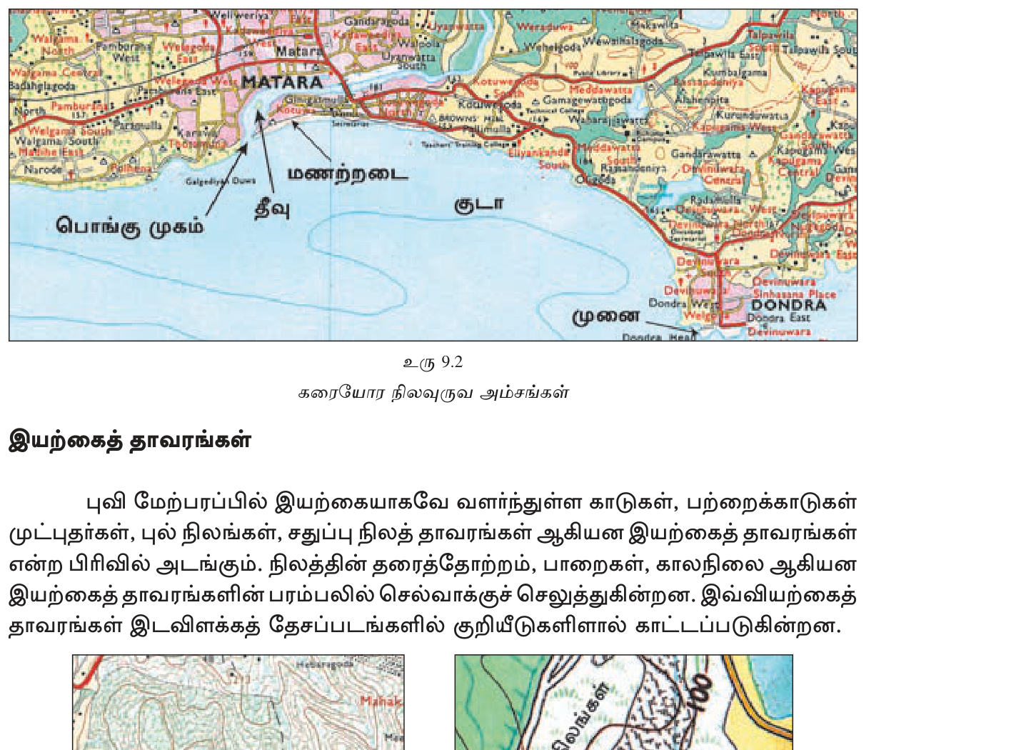
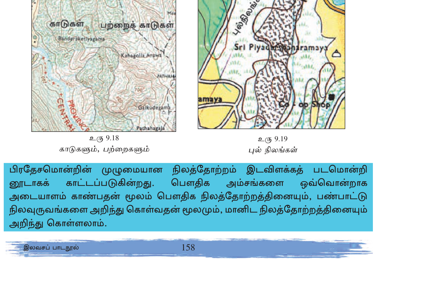
- **Forest (Government)**: **light green shading** + specific labels ("Wilpattu NP", "Sinharaja FR").
- **Scrub jungle**: green dotted pattern.
- **Cultivable lands**: variable green/yellow.
- **Mining/quarrying**: black hatched.
**Sample Integrated Analysis:**
Given a topo sheet of a hill country area, an exam might ask:
*Question 1:* Identify settlement type around Coordinate "345 562".
*Answer:* Looking at the square: black dots clustered around a central feature (likely temple or junction), with road radiating outward. → **Nucleated settlement around junction.**
*Question 2:* What is the predominant land use?
*Answer:* Yellow shading with palm tree dots covering most of the area + green block paddy patches near streams. → **Coconut plantation primary; paddy in valleys.**
*Question 3:* Calculate area of forest reserve shown.
*Answer:* Identify green-shaded forest area; count complete + half grid squares. e.g., 8 complete + 6 half = 11 km².
*Question 4:* Suggest agricultural suitability for a specific point.
*Answer:* Examine slope (contour spacing), drainage (rivers + soil), elevation. e.g., "Slope 1:20 moderate; near stream for irrigation; alluvial valley → suitable for paddy cultivation."
*Question 5:* Identify the type of drainage pattern visible.
*Answer:* Trace streams; observe convergence pattern. e.g., "Tree-branching with multiple tributaries → Dendritic."
**Comprehensive Reading Strategy:**
1. Begin with **edge** (title, scale, key, north arrow, adjacent sheets).
2. Move to **face**: trace major **water features** (blue).
3. Trace major **roads + railways** (red + black).
4. Identify **settlements** + their distribution.
5. Trace **contours** + identify **landforms**.
6. Note **administrative boundaries**.
7. Recognize **land use** patterns.
8. Synthesize: how do features interrelate?
A good topo reader can describe a landscape's geology, economy, settlement history, agricultural potential, transport links — all from one sheet.
🔥 மீட்டல் மையம்
பரீட்சைக்கு முன் இறுதி ஒரு நிமிடம் — மறக்கக்கூடாதவை மட்டும்.
- <b>SL 92 topographic sheets @ 1:50,000.</b> 1 cm = 500m; 2 cm = 1 km; 1 cm² = 0.25 km².
- <b>Each sheet:</b> 5'×5' graticule; ~9km × 9km ground; ~80cm × 80cm map.
- <b>5 reading steps:</b> title+sheet → scale → adjacent sheets → key → grid+north → face.
- <b>Grid System:</b> Eastings FIRST (vertical lines, read L→R); Northings (horizontal lines, read bottom→top). "Along corridor, then up stairs."
- <b>4-fig grid ref:</b> 1km×1km square. e.g., "34 56".
- <b>6-fig grid ref:</b> ~100m × 100m point. Format EEEnnn. e.g., "346 563".
- <b>Contours = brown.</b> CI = 10 or 20m. Index contour every 5th = thicker + labeled.
- <b>Close contours = steep; spaced = gentle. Concentric closed = peak.</b>
- <b>V up-slope = ridge; V down-slope = valley.</b>
- <b>Drainage patterns:</b> Dendritic (common SL), Trellis (folded), Rectangular (jointed), Radial (volcanic), Centripetal (basin), Parallel (slope), Annular (dome), Deranged (glaciated).
- <b>Colors:</b> Blue=water; Brown=contour+dam; Red=roads+admin; Black=rail+settlement; Green=paddy; Yellow=plantation+track.
- <b>Road classes:</b> A=double red solid; B=single red solid; C/D=dashed red.
- <b>Area calc:</b> regular = L×B×0.25 km². Irregular = square count (full + half-squares).
- <b>Gradient:</b> rise/run. 1:5=20% very steep; 1:100=1% gentle.
- <b>Cross-section:</b> vertical profile along line; use ~10× vertical exaggeration.
அலகின் முதுகெலும்பு — கருத்துக்களும் தொடர்புகளும்.
- <b>Sheet basics detailed:</b> SL Survey Department prepares. Each sheet covers 5'×5' (latitude × longitude minutes) graticule. Total 92 sheets cover Sri Lanka. Index sheet shows all 92.
- <b>Scale relationships:</b> 1:50,000 = 1 cm map represents 50,000 cm ground = 500 m = 0.5 km. So 2 cm = 1 km. Area: 1 cm² = 0.25 km² (linear ratio squared!). 1 km² area = 4 cm² on map.
- <b>Grid system fully:</b> Vertical north-south lines = Eastings. Horizontal east-west lines = Northings. Lines spaced 2 cm = 1 km apart. 4-fig reference identifies 1×1 km square using west + south edge values. 6-fig reference adds tenths within square — east-tenth + north-tenth — gives ~100 m × 100 m precision.
- <b>Contour rules detailed:</b> Equal-elevation curves. SL maps brown color. CI 10 or 20m typical. Index contour every 5th (e.g., if CI=10m, index every 50m) — thicker, labeled. Spacing = slope (close=steep, spaced=gentle). Direction matters: V opening UP toward higher contour = ridge; V opening DOWN toward lower contour = valley. Concentric closed loops = peak (innermost highest); closed loops with hachures = depression (innermost lowest).
- <b>10 landform types to identify:</b> Peak (concentric); Plateau (closed wide); Plain (no/wide contours); Ridge (V up-slope); Valley (V down-slope); Slope (parallel); Cliff (touching contours); Waterfall (contours crossing stream); Depression (closed with hachures); Isolated hill (lone peak surrounded by lowland).
- <b>8 drainage patterns:</b> Dendritic (tree, soft rock, SL Mahaweli/Kelani/Kalu); Trellis (perpendicular, folded sedimentary); Rectangular (right angles, jointed/faulted); Radial (outward, volcanic cones); Centripetal (inward, basins); Parallel (slope-controlled); Annular (rings, eroded domes); Deranged (chaotic, glaciated).
- <b>River features:</b> Source, confluence, tributary, distributary, meander (mature river loops), oxbow lake (cut-off meander), braided river (multiple channels), delta (river splits at mouth), waterfall, rapids, estuary.
- <b>Coastal features:</b> Headland/cape (projection); Bay (sea curve into land); Lagoon (partially enclosed coastal water — Negombo, Madu Ganga); Estuary (river mouth + tidal); Delta (river-built fan); Spit/sandbar (narrow projection); Island; Peninsula (Jaffna); Reef (submerged ridge); Beach.
- <b>Settlement types:</b> Dispersed (isolated houses spread — rural agri); Nucleated (clustered around center — village/town); Linear (along road/river/coast); Compact urban (dense built-up shading).
- <b>Transport hierarchy:</b> A class solid double red (e.g. A1 Colombo-Kandy); B class solid single red; C/D dashed red; footpath/cart track dashed black or yellow; railway solid black with ties.
- <b>Religious + civic symbols:</b> Buddhist stupa/dagoba; Hindu kovil tower; Mosque crescent; Church cross; School building; Hospital red cross; Police P; Post Office PO; Trig point ▲.
- <b>Administrative boundaries:</b> District (thick red dashed); DS Division (medium); GN Division (thin); National park (green dashed); Forest reserve (green solid).
- <b>Land use:</b> Paddy green block (often terraced in hills); Tea estate yellow w/ notation; Coconut yellow w/ palm dots; Rubber yellow w/ notation; Forest light green shading; Scrub jungle green dotted; Mining black hatched.
- <b>Distance methods:</b> Straight ruler × 0.5 km/cm. Curving = thread/string method (lay along curves, measure straightened). Or compass small steps.
- <b>Area methods:</b> Rectangular = length × breadth × 0.25 km²/cm². Irregular = square count (full + half squares; full square = 1 km², half = 0.5 km²).
- <b>Gradient calc:</b> Rise (vertical) ÷ Run (horizontal). Convert to same units. e.g., 600m rise over 3000m = 1:5 = 20%. Classifications: 1:5+ very steep; 1:10 steep; 1:20 moderate; 1:50 gentle; 1:100 nearly flat.
- <b>Cross-section drawing:</b> Choose A-B line. Mark each contour intersection along strip of paper. Plot on graph paper: horizontal = distance (map scale); vertical = elevation. Use ~10× vertical exaggeration. Connect smoothly. Label peaks + valleys + rivers.
பரீட்சைக்கு முந்தின இரவு முழு அலகையும் ஓட்டிப் பார்.
- <b>Quick facts:</b> 92 sheets @ 1:50,000. 1 cm = 500m, 2 cm = 1 km, 1 cm² = 0.25 km². Each sheet 5'×5' graticule. CI typically 10-20 m. Index contour every 5th = thicker.
- <b>Grid mnemonic:</b> "Along corridor, then up stairs" = Eastings (left-right) FIRST, Northings (bottom-up) SECOND. "E before N" alphabetically.
- <b>4-fig vs 6-fig:</b> 4-fig identifies 1 km × 1 km square; 6-fig pinpoints ~100m × 100m point. Format 6-fig: EEEnnn (e.g., "346 563").
- <b>Contour rules summary:</b> Brown lines. Close=steep; spaced=gentle. Concentric closed=peak. V up-slope=ridge; V down-slope=valley. Index contour every 5th = thicker.
- <b>8 drainage patterns (memorize):</b> Dendritic, Trellis, Rectangular, Radial, Centripetal, Parallel, Annular, Deranged. Most common in SL = Dendritic.
- <b>Colors:</b> Blue water; Brown contour; Red roads/admin; Black rail/settlement; Green paddy; Yellow plantation/track.
- <b>Calculation formulas:</b> Distance = cm × 0.5 km/cm. Area regular = L × B × 0.25 km²/cm². Area irregular = squares × 1 km². Gradient = rise/run.
- <b>Cross-section:</b> Strip paper along section; mark contour crossings; plot on graph; ~10× vertical exaggeration for visibility.
- <b>எளிதில் தவறும்:</b> (1) Eastings before Northings (E before N). (2) 4-fig vs 6-fig confusion. (3) 1 cm² = 0.25 km² (NOT 1 km²!). (4) V up-slope = ridge, NOT valley. (5) Gradient should be ratio or %. (6) Use scale 0.5 km/cm consistently. (7) Brown = contour (NOT blue or red).
- <b>கட்டுரைக்குத் தயார்:</b> (1) Sheet basics + grid system + 4/6-fig refs + calculations. (2) Contour interpretation + landforms + 8 drainage patterns + river features. (3) Cultural features + symbols + integrated map analysis.
- <b>Sample exam tasks:</b> (1) Give 6-fig grid reference. (2) Calculate distance straight + along road. (3) Identify slope type between two contours. (4) Name drainage pattern. (5) Identify a landform. (6) List settlement type + transport. (7) Calculate area. (8) Calculate gradient. (9) Draw cross-section. (10) Suggest land use possibilities.
- <b>SL-specific knowledge:</b> Major rivers (Mahaweli, Kelani, Kalu); Tea/coconut/rubber zones; Wet/dry zone; Settlement patterns (dispersed in dry zone, nucleated in wet); Survey Department Kirulapone.