உலகில் இயற்கை இடர்கள்
2004 டிசம்பர் 26: அந்த நாள் இலங்கையினருக்கு எளிதில் மறக்க முடியாதது. சுமத்திராவில் (இந்தோனேசியா) கடற்தடி நில நடுக்கம் ஏற்படுத்திய சுனாமி (tsunami) நமது கடற்கரையை மட்டுமன்றி, இந்து சமுத்திரத்தைச் சுற்றியுள்ள 14 நாடுகளையும் தாக்கியது; 2.3 லட்சம் பேர் இறந்தனர். அந்த ஒரு நிகழ்வு புவியின் வாழ்விற்கு இயற்கை இடர்களின் (Natural Hazards) சக்தியை உலகத்திற்கே நினைவூட்டியது. இவ்வலகில் (1) நிலநடுக்கம், (2) எரிமலை, (3) சுனாமி, (4) சூறாவளி, (5) வெள்ளம், (6) வறட்சி, (7) காட்டுத் தீ, (8) நிலச்சரிவு ஆகிய உலகின் முக்கிய இயற்கை இடர்களின் காரணம், பகிர்வு, தாக்கம், மேலாண்மை ஆகியவற்றை அறிவோம். அடுத்த அலகில் இலங்கையின் இயற்கை இடர்களைக் கற்போம்.
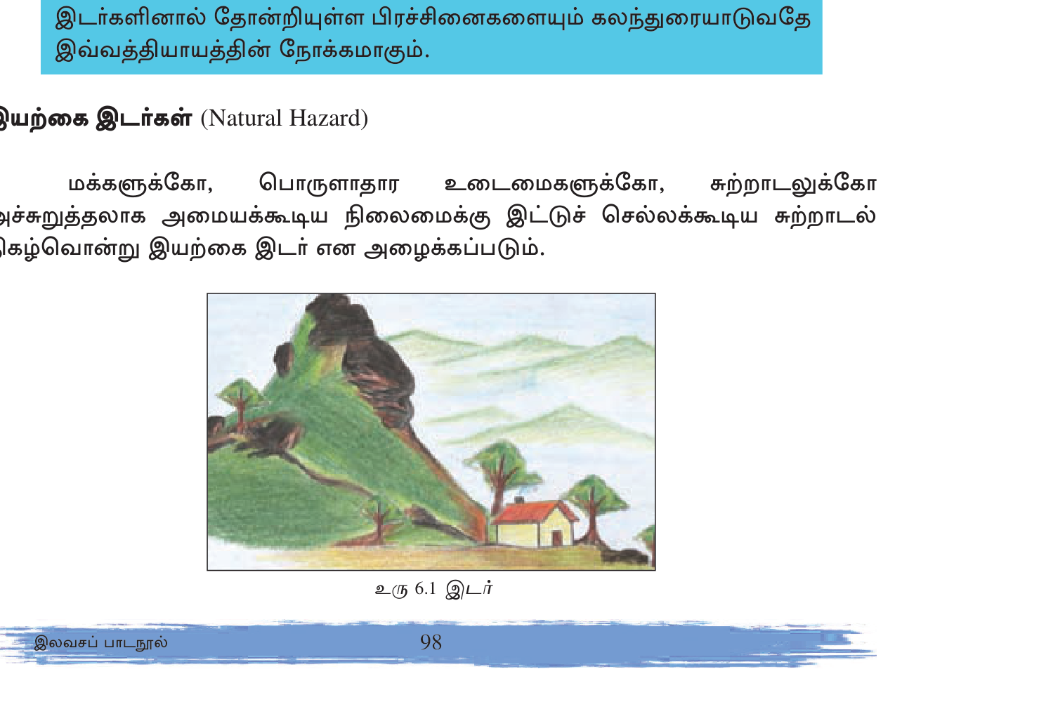
1. இயற்கை இடரும் (Natural Hazard) பேரிடரும் (Disaster)
முதலில் இவ்விரு சொற்களுக்கும் இடையிலான வேறுபாட்டைத் தெளிவுபடுத்துவோம்; இது பரீட்சையில் தவறாமல் கேட்கப்படுவது:
- Natural Hazard (இயற்கை இடர்): நிலநடுக்கம், மழை, காற்று போன்ற ஒரு இயற்கை நிகழ்வு பெரியதாக இருந்தாலும் மக்கள் வாழாத பகுதியில் நிகழ்ந்தால் அது வெறும் hazard மட்டுமே. சகாரா மத்தியில் ஏற்படும் நிலநடுக்கம் hazard ஆகும்; ஆனால் பேரிடர் அல்ல.
- Disaster (பேரிடர்): Hazard ஆனது vulnerable population/property உடன் சந்தித்துப் பெரும் சேதத்தையும் உயிரிழப்பையும் ஏற்படுத்தும்போது அதுவே disaster. அதே நிலநடுக்கம் டோக்கியோ நகரத்தில் ஏற்பட்டால் அது பெரும் disaster ஆகும்.
Formula: Risk = Hazard × Vulnerability × Exposure ÷ Capacity. Disaster Risk Reduction (DRR)
என்பது பாதிக்கப்படும் தன்மையையும் (vulnerability) வெளிப்பாட்டையும் (exposure) குறைத்து, திறனை (capacity) அதிகரிப்பதாகும்.
2. நிலநடுக்கம் (Earthquake)
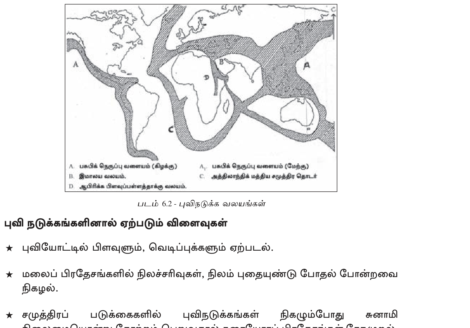
காரணம் — Plate Tectonics
புவியின் மேற்தோடு (crust) ~7 முக்கிய, 8+ சிறு tectonic plates ஆகப் பிரிக்கப்பட்டுள்ளது. இவை ஆண்டுக்கு cm அளவில் நகர்கின்றன. Plates சந்திக்கும் எல்லைகளில் (boundaries) அதிக அழுத்தம் (stress) சேர்ந்து, அது திடீரென விடுவிக்கப்படும்போது நிலநடுக்கம் (earthquake) ஏற்படுகிறது. எல்லைகள் 3 வகைப்படும்:
- Convergent (collision): Two plates push together; one subducts (dives under). E.g. Indo-Australian under Eurasian → Himalayas + earthquakes (Nepal 2015 M7.8 — 9000 dead).
- Divergent (spreading): Plates pull apart; new crust forms. E.g. Mid-Atlantic Ridge, East African Rift.
- Transform (sliding): Plates slide past horizontally. E.g. San Andreas Fault California (San Francisco 1906, Loma Prieta 1989).
அளவீடு (Measurement)
- Magnitude (Richter / Moment Magnitude Scale): energy released. Logarithmic — M6→M7 = 32x energy.
- Mercalli Intensity: observed damage at location (I-XII).
- Seismograph instrument records.
பகிர்வு (Distribution)
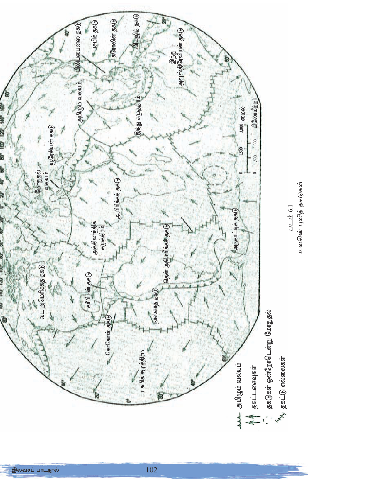
- Pacific \"Ring of Fire\" — Pacific Ocean rim. 80% of world earthquakes! Japan, Indonesia, Philippines, Chile, USA West Coast, Alaska.
- Alpine-Himalayan Belt — Mediterranean → Turkey → Iran → Himalayas → Indonesia. 15%.
- Mid-Atlantic Ridge — divergent boundary, moderate.
- East African Rift — divergent.
அண்மைய பெரும் நிலநடுக்கங்கள் (Major recent)
- 2010 Haiti M7.0 — 230,000 dead; vulnerable construction.
- 2011 Tohoku Japan M9.1 — triggered Fukushima tsunami + nuclear disaster.
- 2015 Nepal M7.8 — Gorkha + Mt Everest avalanche; 9000 dead.
- 2023 Turkey-Syria M7.8 — 60,000+ dead.
மேலாண்மை (Management)
- Building codes — seismic-resistant construction (Japan, NZ, California gold standard).
- Early warning systems — P-wave detection alerts seconds before S-wave (Japan, Mexico, USA West).
- Drills + education — Japan school drills.
- Land-use planning — avoid faults.
- Insurance + emergency funds.
3. எரிமலை (Volcano)
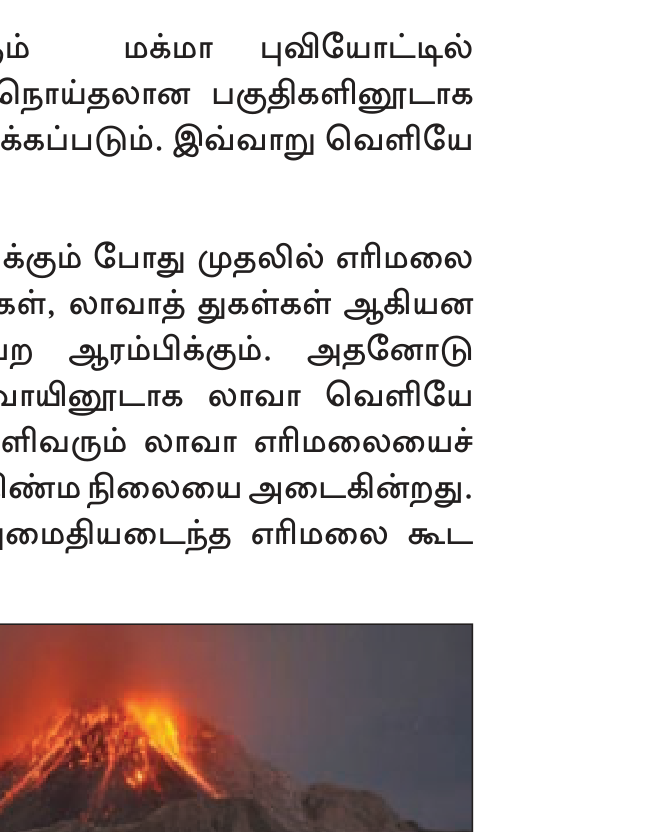
உருவாக்கம்
புவியின் கீழ் உருகிய பாறையான magma, மேற்தோடு (crust) வழியே மேலே வந்து வெளியேறும் திறப்பே (opening) எரிமலை (volcano) எனப்படும். வகைகள்:
- Active — recent eruption / current activity. E.g. Mount Etna (Italy), Kilauea (Hawaii).
- Dormant — has not erupted recently but could. E.g. Mount Fuji (Japan — last 1707).
- Extinct — geological history but unlikely to erupt. E.g. Mount Kilimanjaro (Tanzania).
பகிர்வு
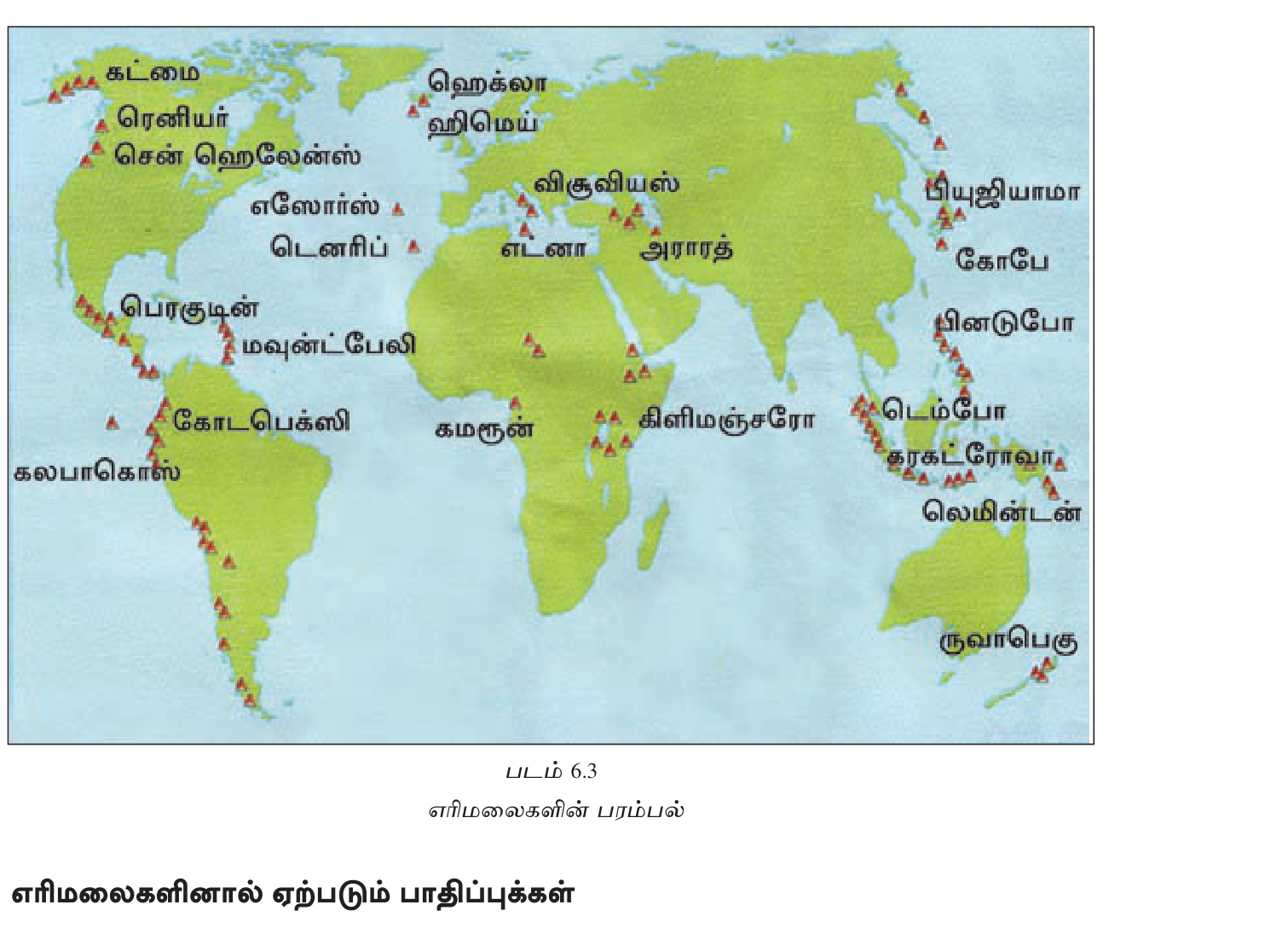
- Pacific Ring of Fire — 75% world's active volcanoes (~750+). Japan, Indonesia, Philippines, USA West, Chile.
- Mid-Atlantic Ridge — Iceland, Azores.
- East African Rift — Kilimanjaro, Mt Kenya, Nyiragongo (DRC).
- Hotspots — Hawaii, Yellowstone — not at plate boundaries.
பெரும் எரிமலைகள்
- 79 AD Vesuvius (Italy) — Pompeii buried.
- 1883 Krakatoa (Indonesia) — 36,000 dead; global cooling.
- 1980 Mount St Helens (USA) — 57 dead.
- 1991 Pinatubo (Philippines) — global cooling 0.5°C 2 yrs.
- 2021 Cumbre Vieja (La Palma, Spain).
- 2022 Hunga Tonga — largest atmospheric explosion since Krakatoa.
4. சுனாமி (Tsunami)
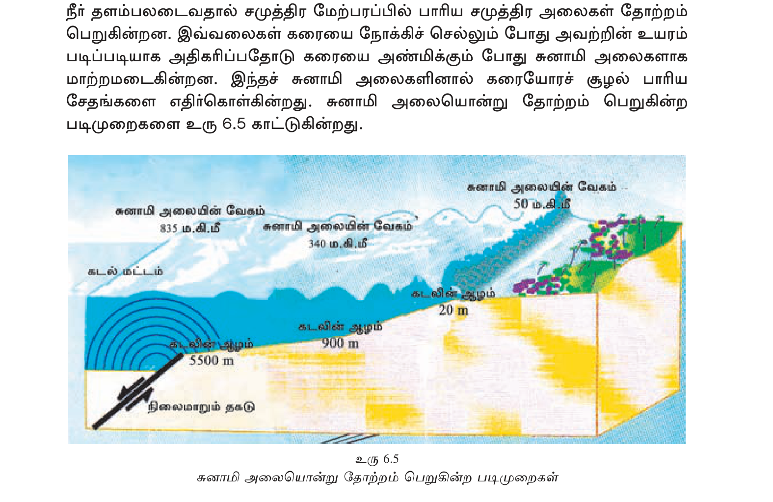
ஜப்பானிய மொழிச் சொல்: \"tsu\" (harbour) + \"nami\" (wave). கடற்தடி நிலநடுக்கம், எரிமலை, நிலச்சரிவு, asteroid impact ஆகியவற்றால் வெளிக் கடலில் நீர் மட்டம் குழம்பி (disturbance), அலைகள் பல்லாயிரம் km தூரம் பரவுகின்றன (wave radiates). கடலில் wave height சிறிது (~1m); ஆனால் வேகம் jet-plane போன்றது (700-800 km/h). கரை சேரும்போது நீர் ஆழமற்றதாகும் (shallow water), அதனால் height shoots up to 10-30m even 50m+. \"Train of waves\" — first not always largest.\n
பெரும் சுனாமிகள்
- 2004 Boxing Day (Indian Ocean) M9.1 — Sumatra epicenter. 14 country impact (SL/India/Thailand/Maldives/Somalia). ~230,000 dead; SL 35,000+.
- 2011 Tohoku Japan — M9.1 quake → Fukushima nuclear meltdown. 18,000 dead.
- 1755 Lisbon — Portugal capital destroyed by quake+tsunami+fire.
Tsunami Warning Systems
- Pacific Tsunami Warning Center (PTWC) — Hawaii since 1949.
- Indian Ocean Tsunami Warning System (IOTWS) — established after 2004 (which had NO warning system at the time).
- DART buoys (Deep-ocean Assessment & Reporting of Tsunamis).
- SMS + siren coastal alerts.
5. சூறாவளி (Cyclones / Hurricanes / Typhoons)
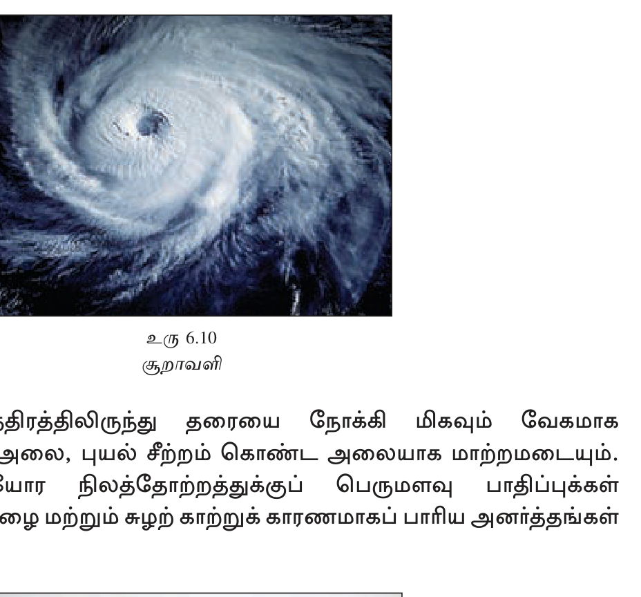
Tropical low-pressure system rotating + intense winds + heavy rain. பிராந்தியத்திற்கு ஏற்ற பெயர்கள்:
- Cyclone — Indian Ocean + South Pacific.
- Hurricane — North Atlantic + Northeast Pacific.
- Typhoon — Northwest Pacific (Japan/Philippines/China).
- (Same phenomenon, different names.)
உருவாகத் தேவையான நிலைமைகள்
- Sea surface temperature 26.5°C+.
- Latitude 5-20° from equator (need Coriolis force; not on equator).
- Low wind shear.
- Pre-existing disturbance.
பகிர்வும் பருவமும் (Season)
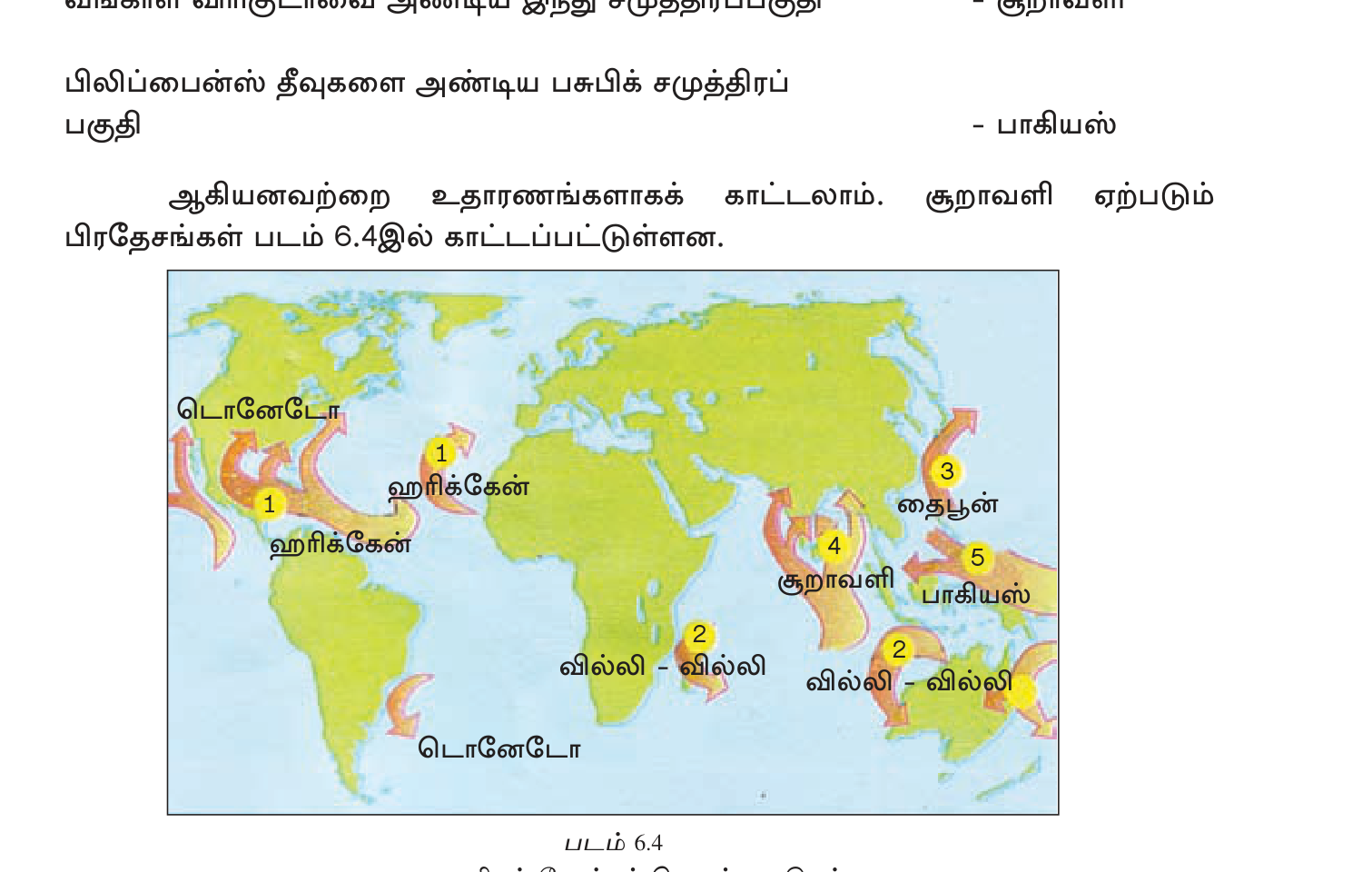
- North Atlantic (hurricanes): Jun-Nov. Caribbean, Gulf of Mexico, US Atlantic coast. Saffir-Simpson scale Cat 1-5.
- NW Pacific (typhoons): year-round, peak Jul-Oct. Philippines, Japan, China, Vietnam.
- Bay of Bengal cyclones: Oct-Nov, Apr-May. India, Bangladesh, Myanmar, SL.
- Arabian Sea cyclones: Apr-Jun, Oct-Dec. Yemen, Oman, Pakistan, Gujarat.
- South Pacific cyclones: Nov-Apr (Southern Hemisphere summer).
- South Indian Ocean: Nov-Apr. Madagascar, Mozambique.
பெரும் சூறாவளிகள்
- 1970 Bhola Cyclone (Bangladesh/East Pakistan) — 300,000-500,000 dead; deadliest in history.
- 1991 Bangladesh — 138,000.
- 2005 Hurricane Katrina (USA) — New Orleans flooded; 1,800 dead.
- 2008 Cyclone Nargis (Myanmar) — 138,000.
- 2013 Typhoon Haiyan (Philippines) — 6,300; Cat 5 winds 315 km/h.
- 2017 Atlantic season — Harvey/Irma/Maria — Puerto Rico devastated.
- 2020 Cyclone Amphan (Bay of Bengal) — India/Bangladesh.
6. வெள்ளம் (Floods)
Excess water beyond drainage capacity. Types:
- River flood — heavy rain / snowmelt → river overflows. Mississippi, Yangtze, Ganges-Brahmaputra.
- Flash flood — intense rain on small catchment → minutes to hours. Mountain, urban.
- Coastal flood / Storm surge — cyclone push sea inland.
- Urban flood — drainage overwhelmed by paved surfaces.
- Glacial Lake Outburst Flood (GLOF) — Himalayan, Andean.
பெரும் வெள்ளங்கள்
- 1931 Yangtze China — 4 million dead; deadliest natural disaster ever.
- 1998 China Yangtze — 3,000+ dead, 15M displaced.
- 2010 Pakistan Indus — 20M affected.
- 2011 Thailand — Bangkok flooded.
- 2017 Houston Hurricane Harvey — record rainfall.
- 2022 Pakistan — 1/3 of country submerged.
7. வறட்சி (Drought)
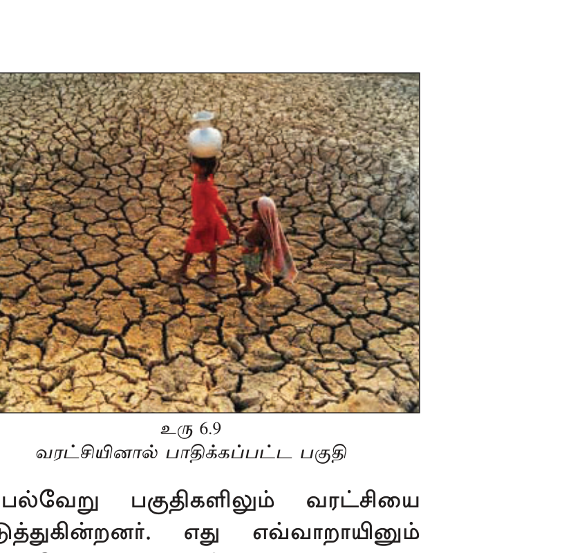
Prolonged below-average rainfall → water shortage → agricultural + food + health crisis. வகைகள்:
- Meteorological drought — rainfall < long-term average.
- Hydrological — surface + groundwater low.
- Agricultural — soil moisture insufficient for crops.
- Socioeconomic — water demand exceeds supply.
பெரும் வறட்சிகள்
- Dust Bowl (1930s USA) — Great Plains, agricultural collapse, 2.5M displaced.
- Sahel drought (1968-85) — sub-Saharan; 100,000+ dead, millions migrated.
- 1984-85 Ethiopia — 1 million dead; \"Band Aid\" Live Aid 1985.
- 2011-22 Horn of Africa — Somalia, Ethiopia, Kenya recurring.
- 2018 Cape Town \"Day Zero\" — first major city near water cutoff.
- 2022 Europe — Rhine + Po + Loire historic lows.
8. காட்டுத் தீயும் நிலச்சரிவும் (Wildfires, Landslides)
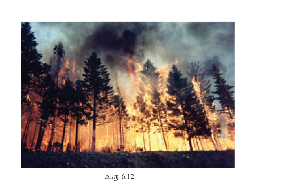
Wildfires
Dry vegetation + heat + ignition (lightning + human). Climate change-enhanced. பெரிய நிகழ்வுகள்:
- 2019-20 Australia — \"Black Summer\" 18M hectares burnt, 33 dead, 3B animals.
- 2018 California Camp Fire — 85 dead, Paradise town destroyed.
- 2023 Canada — 18M hectares record; smoke reached USA.
- 2023 Greece + Hawaii Maui — climate emergency events.
- Amazon burning annually for cattle/soy.
Landslides
Steep slope + heavy rain / earthquake / deforestation → mass movement. Predominantly mountainous regions. Major: 1970 Peru (Mount Huascarán — 22,000 dead), 2014 Oso USA, 2017 Sierra Leone Freetown (1,141 dead).
9. பேரிடர் மேலாண்மை (Disaster Management): பொதுக் கட்டமைப்பு
UN Disaster Risk Reduction (UNDRR) — \"Sendai Framework 2015-2030\" 4 priorities:
- Understanding disaster risk — hazard mapping, vulnerability assessment.
- Strengthening governance — laws, institutions, coordination.
- Investing in resilience — infrastructure, ecosystems, social safety nets.
- Enhancing preparedness — early warning, evacuation plans, training.
Disaster Management Cycle: Mitigation (prevent/reduce) → Preparedness (plan) → Response (emergency action) → Recovery (rebuild + learn).
- Hazard vs Disaster: Hazard = natural event; Disaster = hazard × vulnerable population.
- Earthquake: Plate tectonics; Pacific Ring of Fire = 80% world quakes. Richter logarithmic.
- 3 boundary types: Convergent · Divergent · Transform.
- 2004 Indian Ocean Tsunami: M9.1 Sumatra → 14 countries, 230,000 dead. SL 35,000+.
- 2011 Tohoku Japan: M9.1 → Fukushima nuclear disaster.
- Volcanoes: 75% in Pacific Ring of Fire. 3 states: Active/Dormant/Extinct.
- Cyclone names: Cyclone (Indian Ocean) / Hurricane (Atlantic) / Typhoon (NW Pacific).
- Formation needs: SST 26.5°C+, lat 5-20° (not equator), low shear.
- 1970 Bhola Cyclone Bangladesh — deadliest 300-500K dead.
- 1931 Yangtze flood — 4M dead, deadliest single disaster ever.
- Drought types: Meteorological · Hydrological · Agricultural · Socioeconomic.
- Sendai Framework 2015-2030 — UN DRR.
- Disaster Mgmt Cycle: Mitigation → Preparedness → Response → Recovery.
- "Hazard = Disaster" — different. Hazard without people = no disaster.
- "Tsunami = big wave only" — series of waves; first not always largest; speed jet-plane in deep ocean.
- "Hurricane on equator possible" — NO. Coriolis force = 0 at equator; cyclones form 5-20°.
- "Active vs Dormant volcano" — Active = recent erupt; Dormant = could erupt; Extinct = won\'t.
- Richter scale logarithmic — M6 → M7 = 32× energy (not 10×).
- 2004 tsunami affected MORE than SL — 14 countries including India, Thailand, Maldives, Somalia.
- Drought ≠ no rain immediately — \"prolonged\" deficit; develops slowly.
- Sahel ≠ Sahara — Sahel is semi-arid band SOUTH of Sahara; drought-prone agricultural land.
- SL is NOT typhoon-prone — SL on cyclone path (Bay of Bengal), not typhoon (NW Pacific).
✅ விரைவுச் சோதனை
முக்கியக் கருத்துக்களை உறுதிப்படுத்துங்கள். தவறான விடைகள் உங்கள் தவறுக் குறிப்பேட்டில் சேமிக்கப்படும்.
🖊 கட்டுரை வினாக்கள் (பகுதி II)
பரீட்சை வடிவில் கட்டமைப்பு வினாக்கள். முதலில் நீங்களே எழுதுங்கள்; பின்னர் மாதிரி விடையைத் திறந்து சரிபாருங்கள்.
விடைத் திட்டம் — சேர்க்க வேண்டிய புள்ளிகள்:
- Hazard=event; Disaster=hazard+vulnerable people
- Earthquake: tectonic plates; Ring of Fire 80%
- Volcano: magma to surface; 3 states; Ring of Fire 75%
- Tsunami: undersea quake/volcano; 700-800 km/h
- Cyclones/Hurricanes/Typhoons regional naming
- Sendai Framework 2015-30
**Formula:** Risk = Hazard × Vulnerability × Exposure ÷ Capacity. Disaster Risk Reduction (DRR) reduces vulnerability + exposure + increases capacity.
**1. Earthquakes (நிலநடுக்கம்):** Caused by plate tectonics — Earth's crust 7+ major plates moving ~cm/year. Boundaries: (a) Convergent — collision (Indo-Australian under Eurasian = Himalayas); (b) Divergent — spreading (Mid-Atlantic Ridge, East African Rift); (c) Transform — sliding (San Andreas California). Distribution: Pacific Ring of Fire 80%, Alpine-Himalayan belt 15%, others 5%. Measurement: Richter/Moment Magnitude scale (logarithmic — M6→M7 = 32× energy), Mercalli intensity scale (I-XII observed damage). Recent: 2010 Haiti M7.0 (230K dead from vulnerable construction); 2011 Tohoku Japan M9.1 (Fukushima nuclear triggered); 2015 Nepal Gorkha M7.8 (9K dead, Everest avalanche); 2023 Turkey-Syria M7.8 (60K+ dead).
**2. Volcanoes (எரிமலை):** Magma (molten rock) escapes through crustal openings. States: Active (recent erupt — Etna, Kilauea), Dormant (could erupt — Mt Fuji last 1707), Extinct (won't — Kilimanjaro). Distribution: 75% in Pacific Ring of Fire (750+ active), Mid-Atlantic Ridge (Iceland), East African Rift, hotspots (Hawaii, Yellowstone). Major: 79 AD Vesuvius (Pompeii buried), 1883 Krakatoa Indonesia (36K dead + global cooling), 1991 Pinatubo Philippines (0.5°C global cooling 2 yrs), 2022 Hunga Tonga (largest explosion since Krakatoa).
**3. Tsunamis (சுனாமி):** Japanese 'harbour wave.' Undersea earthquake / volcanic eruption / landslide / asteroid displaces water → radiates outward. Deep ocean: 1m height but 700-800 km/h speed. Shallow shore: height shoots to 10-50m. "Train of waves" — first not always largest. **2004 Boxing Day Indian Ocean (M9.1 Sumatra):** 14 countries impacted, ~230K dead, SL ~35K. NO warning system at time → IOTWS established post-2006. **2011 Tohoku Japan:** M9.1 → Fukushima nuclear meltdown + 18K dead. **1755 Lisbon Portugal:** earthquake+tsunami+fire combined.
**4. Cyclones/Hurricanes/Typhoons (சூறாவளி):** Same phenomenon, region-specific naming. Cyclone (Indian Ocean), Hurricane (Atlantic), Typhoon (NW Pacific). Formation requires: sea temperature 26.5°C+, latitude 5-20° (Coriolis force; NOT at equator), low wind shear, moisture. Structure: calm "eye" surrounded by intense "eye wall" + spiral rainbands. Distribution + seasons: NW Pacific year-round; Atlantic Jun-Nov; Bay of Bengal Oct-Nov+Apr-May; Arabian Sea Apr-Jun+Oct-Dec; South Pacific/Indian Nov-Apr.
Deadly cyclones: **1970 Bhola** (Bangladesh/E.Pakistan) ~300-500K dead — deadliest tropical cyclone in history. **1991 Bangladesh** 138K. **2008 Nargis Myanmar** 138K. **2005 Katrina USA** New Orleans flooded, 1,800 dead. **2013 Haiyan Philippines** Cat 5 (315 km/h winds), 6,300 dead. **2017 Atlantic season** Harvey/Irma/Maria devastating Puerto Rico. **2020 Amphan Bay of Bengal** India/Bangladesh.
**Management Framework — Sendai 2015-2030 (UN DRR):** 4 priorities — Understand risk (mapping), Strengthen governance (institutions), Invest in resilience (infrastructure + safety nets), Enhance preparedness (warning + drills). Disaster Mgmt Cycle: Mitigation → Preparedness → Response → Recovery → back to Mitigation.
விடைத் திட்டம் — சேர்க்க வேண்டிய புள்ளிகள்:
- Dec 26 2004 M9.1 off Sumatra Indonesia
- Indian Ocean tsunami; 14 country impact
- 230K+ dead; SL 35K+; India, Indonesia, Thailand, Maldives, Somalia
- SL particularly E + S coasts; Yala/Trincomalee/Galle
- Causes: undersea quake → uplift
- No warning system at time
- Aftermath: IOTWS 2006 established
- SL response: reconstruction, Disaster Management Centre
- Tourism rebuild; global aid wave
**Cause Detail:** Subduction zone — Indo-Australian plate moving NE at ~5 cm/year was locked against the overriding Burma microplate. Stress accumulated for ~200 years released in 600+ km rupture lasting 8-10 minutes (one of longest recorded). Energy ~10^23 joules — equivalent to all electricity USA uses for several months. Seafloor uplifted ~10m vertically; horizontal displacement up to 20m.
**Tsunami Propagation:** From epicenter waves radiated outward at 500-800 km/h (similar to a jet airliner) across Indian Ocean. Wave height in deep water only ~1m but undetected. As waves approached shallow coastlines, water column piled up — wave heights of 9-30m struck various coasts. Multiple waves; first not necessarily largest. Reached Sri Lanka ~2 hours after quake; Africa ~7 hours.
**Affected Countries (14):**
1. **Indonesia** (Aceh, Sumatra) — closest to epicenter; ~170,000 dead, hundreds of thousands missing.
2. **Sri Lanka** — Eastern + Southern coasts devastated; ~35,000-40,000 dead, 500,000+ displaced. Yala wildlife park engulfed; Galle, Hambantota, Matara, Batticaloa, Trincomalee severe.
3. **India** — Tamil Nadu coast + Andaman-Nicobar; ~16,000 dead.
4. **Thailand** — Phuket + Phi Phi tourist beaches; ~5,400 dead including 2,100 tourists.
5. **Maldives** — entire archipelago at sea level; 82 dead, country economically devastated.
6. **Somalia** — East African coast; ~300 dead.
7. **Myanmar** — Tanintharyi region; ~70 dead (likely underreported by junta).
8. **Malaysia** — Penang island; 80 dead.
9. **Tanzania** — 13 dead.
10. **Bangladesh** — 2 dead (sheltered geography).
11. **Kenya** — 1 dead.
12. **Madagascar** — modest damage.
13. **Seychelles** — damage.
14. **South Africa** — minor surge.
**Total: ~230,000-280,000 dead** (figures vary by source). Estimated ~2 million displaced.
**Sri Lanka Impact in Detail:**
- Eastern Province (Trincomalee, Batticaloa, Ampara) most affected.
- Southern coast (Galle Fort survived; Tangalle, Hambantota severe).
- Famous **Peraliya train disaster** — Queen of Sea express overrun by wave; ~1,700 passengers dead — deadliest single train disaster in history.
- **Yala National Park** — wildlife sensed and fled inland; remarkable behaviour story.
- Tourist beaches (Unawatuna, Mirissa, Bentota, Negombo) ravaged just before peak Christmas-New Year season.
- 800,000 displaced into IDP camps; 200,000+ children lost a parent.
- Tamil northeast had no warning + already fragile from civil war.
- Brief LTTE-government truce around relief — quickly broke down.
- Economic loss ~$1 billion (4-5% of GDP); tourism collapsed.
**Why So Devastating?**
- **No Indian Ocean tsunami warning system existed** (Pacific had PTWC since 1949 but Indian Ocean did not).
- **Public awareness near-zero** — most people had never heard the word "tsunami." In SL local language, no equivalent term.
- **Coastal populations dense** — fishing villages, tourism resorts.
- **2-hour warning window unused** — even when Indonesia knew within minutes, no protocol to alert SL/India/Africa.
- **First wave smaller in some places** — people went out to look at strange exposed seabed → killed by larger second/third wave.
- **Boxing Day weekend** — relaxed atmosphere, lots of tourists on beaches.
**International Response:**
- **Largest humanitarian operation in history at the time** — UN, Red Cross, IFRC, NGOs, militaries.
- **$13 billion+ pledged** globally; individual donations from Western publics record.
- **NATO + US military** logistics support.
- **Indian Ocean Tsunami Warning System (IOTWS) established 2006** under UNESCO IOC; DART buoys, coastal sirens, SMS alerts, Indonesia-India regional centres.
- **Sendai Framework precursor** — Hyogo Framework 2005 emerged partly from this event.
**Sri Lanka's Aftermath + Reform:**
- **Disaster Management Centre (DMC) established 2005** under PM's office; Disaster Management Act 2005.
- **Coastal Conservation Department** strengthened building regulations.
- **"Build back better"** philosophy — coastal setbacks (100m+) imposed.
- **Mangrove + coral reef restoration** — natural barriers.
- **Tsunami evacuation route signage** + drills along coast.
- **Memorials** — Peraliya train, statue at Hambantota.
- **Long-term recovery 5-7 years** — housing, livelihoods.
- Some critique: post-tsunami coastal land grabs by developers; displaced fishing families never returned home.
**Lessons Learned:**
1. Trans-oceanic tsunamis = real & devastating beyond Pacific.
2. Warning systems must be GLOBAL.
3. Coastal vulnerability + climate change worsening risks.
4. Education + drills = save lives.
5. Disasters affect poor disproportionately.
6. Mangroves + reefs as natural defenses.
2004 changed humanity's relationship with the sea, with tsunami science, with disaster preparedness — and brought together rival nations (India/Pakistan, US/Iran briefly) in shared grief + relief.
விடைத் திட்டம் — சேர்க்க வேண்டிய புள்ளிகள்:
- Same phenomenon, regional names
- Formation: SST 26.5+, lat 5-20°, low shear, moisture
- Structure: eye/eye wall/rainbands
- Saffir-Simpson Cat 1-5
- Major: Bhola 1970, Katrina 2005, Haiyan 2013, Sandy 2012, Maria 2017
- Climate change: stronger, more frequent, more rapid intensification
- Bay of Bengal seasonal pattern
- SL on cyclone path (not typhoon)
- **Cyclone** — North Indian Ocean (Bay of Bengal, Arabian Sea) + Southwest Indian Ocean (Madagascar, Mozambique) + South Pacific.
- **Hurricane** — North Atlantic + Northeast Pacific (Mexico, USA, Caribbean).
- **Typhoon** — Northwest Pacific (Japan, Philippines, China, Vietnam, Korea).
**Formation Requirements:**
1. **Warm sea surface temperature ≥ 26.5°C** to depth of 50m. Latent heat from evaporation = primary energy source.
2. **Latitude 5-20° from equator.** Need Coriolis force for rotation; zero at equator → no cyclone can form there or cross it (rare crossings shed structure).
3. **Low wind shear** — strong vertical wind change tears apart developing cyclones.
4. **Pre-existing disturbance** — tropical waves, monsoon troughs.
5. **Moisture supply** — high humidity in mid-troposphere.
6. **Atmospheric instability** — warm rising air.
No cyclones in South Atlantic + Southeast Pacific (cold currents + wind shear suppress).
**Structure:**
- **Eye:** central calm zone, 15-65 km diameter; descending air; clear sky; weakest winds.
- **Eye Wall:** ring of towering thunderstorms encircling eye; STRONGEST winds + heaviest rain.
- **Spiral Rainbands:** outer convective bands extending 100-500+ km; tornadoes embedded.
- **Outflow:** upper-level winds spreading away from top.
- **Storm Surge:** wind-driven sea water piled against coast; usually deadliest aspect.
**Classification — Saffir-Simpson Hurricane Wind Scale:**
- Cat 1: 119-153 km/h (some damage)
- Cat 2: 154-177 (extensive)
- Cat 3: 178-208 (devastating; major)
- Cat 4: 209-251 (catastrophic)
- Cat 5: 252+ (catastrophic; complete failures)
India/IMD uses similar scale with names: Cyclonic Storm → Severe → Very Severe → Extremely Severe → Super Cyclonic Storm.
**Naming Convention:** Started 1953 (Atlantic), now all basins. Alternating male+female. List rotates every 6 years; retired if catastrophic (Katrina, Sandy, Maria, Haiyan retired). Regional bodies maintain lists.
**Regional Patterns + Seasons:**
| Region | Season | Typical Activity |
|---|---|---|
| NW Pacific | Year-round, peak Jul-Oct | ~25/yr; most active globally |
| North Atlantic | Jun-Nov peak Aug-Oct | ~14/yr |
| Eastern Pacific | May-Nov | ~15/yr |
| Bay of Bengal | Oct-Nov + Apr-May | ~5/yr but disproportionately deadly |
| Arabian Sea | Apr-Jun + Oct-Dec | ~2/yr |
| SW Indian Ocean | Nov-Apr | ~9/yr |
| Australia/SW Pacific | Nov-Apr | ~10/yr |
**Catastrophic Examples:**
1. **1970 Bhola Cyclone (Bangladesh)** — ~300,000-500,000 dead — deadliest tropical cyclone in recorded history. Storm surge in Ganges delta. Political crisis → Bangladesh War of Liberation 1971.
2. **1991 Bangladesh Cyclone (Marian)** — 138,000 dead.
3. **2008 Cyclone Nargis (Myanmar)** — 138,000 dead. Junta blocked international aid initially.
4. **2005 Hurricane Katrina (USA)** — New Orleans flooded; 1,800 dead, $125 billion damage. Levee failures, race/poverty exposed.
5. **2012 Hurricane Sandy (US East Coast)** — NYC subway flooded, $70B damage.
6. **2013 Typhoon Haiyan/Yolanda (Philippines)** — Cat 5 with 315 km/h winds (strongest landfall ever); 6,300 dead, Tacloban devastated.
7. **2017 Atlantic Season** — Harvey (Houston flood), Irma (Caribbean), Maria (Puerto Rico devastated, ~3,000 dead later attributed).
8. **2020 Cyclone Amphan (Bay of Bengal)** — India + Bangladesh, $13B damage. During COVID complicated response.
9. **2022 Atlantic** — Hurricane Ian (Florida).
10. **2024 Hurricane Helene + Milton (US East)** — major US East Coast impacts.
**Storm Surge — Often Deadliest:**
Wind-driven sea level rise can be 5-15m. Bangladesh delta vulnerable. 90% of cyclone deaths historically from surge, not wind.
**Climate Change Connection:**
1. **Warmer SSTs** → more energy → potentially stronger storms.
2. **Rapid intensification** (Cat 1 to 5 in 24h) increasing — 2017 Maria, 2024 Helene/Milton examples.
3. **Slower-moving storms** (steering currents weakening?) → more rain per location (Harvey 2017).
4. **Sea-level rise** → worse storm surge for same wind.
5. **Possibly more frequency** — debate; quality records short.
6. **Heavier rainfall** — atmosphere holds 7% more moisture per °C warming.
IPCC reports: "medium confidence" tropical cyclone intensity is increasing.
**Sri Lanka & Cyclones:** SL is on Bay of Bengal cyclone path but USUALLY on the outer track (most go to India/Bangladesh). Major SL impacts: 1978 Cyclone Bhola Eastern Province; 2004 Hudhud edges; modest. SL more affected by indirect: heavy rain from cyclones passing nearby. NOT typhoon-prone (typhoons are NW Pacific).
**Mitigation:**
- **Early warning** — RSMC (Regional Specialized Meteorological Centres) — IMD India, JMA Japan, NHC USA.
- **Evacuation** — Bangladesh's cyclone shelter program saves tens of thousands; Cuba's mass evacuation success.
- **Building codes** — Florida hurricane-resistant homes.
- **Mangrove + coastal forests** — natural buffer.
- **Insurance + risk financing.**
- **International cooperation** — WMO, IFRC.
🔥 மீட்டல் மையம்
பரீட்சைக்கு முன் இறுதி ஒரு நிமிடம் — மறக்கக்கூடாதவை மட்டும்.
- <b>Hazard vs Disaster:</b> Hazard = natural event; Disaster = hazard + vulnerable population.
- <b>Risk = Hazard × Vulnerability × Exposure ÷ Capacity.</b>
- <b>Earthquake:</b> Plate tectonics; ~7 major plates. 3 boundaries: Convergent + Divergent + Transform. <b>Pacific Ring of Fire = 80% quakes</b>. Richter logarithmic.
- <b>Volcano:</b> 3 states (Active/Dormant/Extinct). <b>75% in Pacific Ring of Fire</b>. VEI 0-8 scale.
- <b>Tsunami:</b> "Harbour wave." Deep ocean 700-800 km/h but 1m height; shallow shore 10-50m.
- <b>2004 Boxing Day Tsunami:</b> M9.1 off Sumatra → 14 countries, ~230K dead. SL 35K+. IOTWS established 2006.
- <b>2011 Tohoku:</b> M9.1 → Fukushima nuclear meltdown.
- <b>Cyclone names:</b> Cyclone (Indian Ocean) / Hurricane (Atlantic) / Typhoon (NW Pacific).
- <b>Formation:</b> SST 26.5°C+, latitude 5-20° (NOT equator), low shear, moisture.
- <b>Saffir-Simpson Cat 1-5.</b> Cat 5 = 252+ km/h.
- <b>Deadliest cyclone:</b> 1970 Bhola Bangladesh ~300-500K dead.
- <b>Deadliest natural disaster ever:</b> 1931 Yangtze flood ~4M dead.
- <b>Sendai Framework 2015-2030</b> 4 priorities.
- <b>Disaster Mgmt Cycle:</b> Mitigation → Preparedness → Response → Recovery.
அலகின் முதுகெலும்பு — கருத்துக்களும் தொடர்புகளும்.
- <b>Plate boundaries detail:</b> Convergent (collision, Indo-Aus under Eurasian = Himalayas + Nepal 2015); Divergent (Mid-Atlantic Ridge, East African Rift); Transform (San Andreas California, 1906 SF + 1989 Loma Prieta).
- <b>Earthquake scales:</b> Richter/Moment Magnitude (energy, logarithmic — M6→M7 = 32× energy); Mercalli Intensity (I-XII observed damage). Seismograph records.
- <b>Major earthquakes:</b> 2010 Haiti M7.0 (230K dead — poor construction). 2011 Tohoku M9.1 (Fukushima). 2015 Nepal Gorkha M7.8 (9K). 2023 Turkey-Syria M7.8 (60K+).
- <b>Volcano examples:</b> 79 AD Vesuvius (Pompeii). 1883 Krakatoa (36K + global cooling). 1980 Mt St Helens (57). 1991 Pinatubo (cooling 0.5°C 2 yrs). 2022 Hunga Tonga (largest atmospheric blast since Krakatoa).
- <b>Volcano types:</b> Active (Etna, Kilauea); Dormant (Fuji 1707 last); Extinct (Kilimanjaro).
- <b>Tsunami detail:</b> Speed = jet plane in deep ocean (700-800 km/h). First wave NOT always largest — "wave train." 2004 NO Indian Ocean warning; 2006 IOTWS established. DART buoys + sirens.
- <b>2004 Tsunami detail:</b> Indo-Australian subducted Burma microplate, 600+km rupture, 8-10 min duration. SL Peraliya train disaster ~1,700 dead (deadliest train disaster ever). $13B+ global aid. SL Disaster Management Centre established 2005.
- <b>Cyclone formation:</b> SST 26.5°C+ to 50m depth, lat 5-20° Coriolis needed, low wind shear, pre-existing disturbance, moisture, instability. No cyclones South Atlantic or SE Pacific (cold currents).
- <b>Cyclone structure:</b> Calm "eye" (15-65km) — descending air. "Eye wall" surrounding — strongest winds + rain. Spiral rainbands (100-500km out). Storm surge = often deadliest aspect.
- <b>Cyclone seasons:</b> NW Pacific year-round peak Jul-Oct (~25/yr); N Atlantic Jun-Nov peak Aug-Oct (~14/yr); Bay of Bengal Oct-Nov+Apr-May (~5/yr but deadliest); Arabian Sea Apr-Jun+Oct-Dec; SW Indian Ocean Nov-Apr.
- <b>Deadly cyclones:</b> 1970 Bhola Bangladesh 300-500K (deadliest ever); 1991 BD 138K; 2008 Nargis Myanmar 138K; 2005 Katrina USA 1,800 ($125B); 2013 Haiyan Philippines Cat 5 315 km/h 6,300 dead; 2017 Maria Puerto Rico ~3,000; 2020 Amphan Bay of Bengal during COVID.
- <b>Floods major:</b> 1931 Yangtze 4M (deadliest disaster ever). 1998 Yangtze 3,000+ 15M displaced. 2010 Pakistan Indus 20M affected. 2017 Houston Harvey record rain. 2022 Pakistan 1/3 country submerged.
- <b>Drought types:</b> Meteorological (rain deficit), Hydrological (water bodies low), Agricultural (soil moisture insufficient), Socioeconomic (demand > supply).
- <b>Major droughts:</b> 1930s Dust Bowl USA (2.5M displaced). 1968-85 Sahel sub-Saharan (millions dead). 1984-85 Ethiopia (1M dead, Live Aid 1985). 2018 Cape Town "Day Zero" (first major city near cutoff). 2022 Europe Rhine/Po/Loire historic lows.
- <b>Wildfires + Landslides:</b> 2019-20 Australia "Black Summer" 18M ha 3B animals. 2018 Camp Fire California 85 dead Paradise destroyed. 2023 Canada record 18M ha. 1970 Peru Mt Huascarán landslide 22K dead.
- <b>Sendai Framework 2015-2030 priorities:</b> (1) Understanding risk (mapping/assessment), (2) Strengthening governance (laws/institutions), (3) Investing in resilience (infrastructure/ecosystems/safety nets), (4) Enhancing preparedness (warning/evacuation/training).
பரீட்சைக்கு முந்தின இரவு முழு அலகையும் ஓட்டிப் பார்.
- <b>Memorize:</b> Pacific Ring of Fire 80% quakes + 75% volcanoes. 2004 Boxing Day = 14 countries 230K. 1970 Bhola = deadliest cyclone 300-500K. 1931 Yangtze = deadliest disaster 4M.
- <b>Cyclone formation:</b> SST 26.5°C, lat 5-20° (NOT equator), low shear. Saffir-Simpson Cat 1-5. Cat 5 = 252 km/h.
- <b>Plate types 3:</b> Convergent + Divergent + Transform.
- <b>Volcano states 3:</b> Active + Dormant + Extinct.
- <b>Drought types 4:</b> Meteorological + Hydrological + Agricultural + Socioeconomic.
- <b>Cyclone naming:</b> Cyclone=Indian Ocean / Hurricane=Atlantic / Typhoon=NW Pacific. SL on cyclone path NOT typhoon.
- <b>Year-Hazard pairs:</b> 79 AD Vesuvius, 1755 Lisbon, 1883 Krakatoa, 1931 Yangtze, 1970 Bhola, 1980 St Helens, 1991 Pinatubo, 2004 Indian Ocean Tsunami, 2005 Katrina, 2008 Nargis, 2010 Haiti, 2011 Tohoku, 2013 Haiyan, 2015 Nepal, 2017 Maria, 2018 Cape Town, 2019-20 Australia, 2022 Pakistan + Hunga Tonga, 2023 Turkey-Syria + Canada.
- <b>எளிதில் தவறும்:</b> (1) Hazard ≠ Disaster. (2) Richter logarithmic NOT linear. (3) Cyclones NOT on equator (Coriolis). (4) First tsunami wave NOT always largest. (5) Active vs Dormant vs Extinct volcano. (6) Saffir-Simpson = cyclone scale; Richter = quake; VEI = volcano. (7) Drought = prolonged deficit (not just no rain today).
- <b>கட்டுரைக்குத் தயார்:</b> (1) Hazard vs disaster + 4 main types. (2) 2004 Indian Ocean Tsunami detail. (3) Cyclones formation + naming + climate change. (4) Disaster management Sendai framework.
- <b>Climate change connection:</b> Stronger storms (more SST energy), rapid intensification, slower movement (more rain), sea-level rise worsens storm surge, more wildfire conditions, drought intensification, glacier melt floods.